You are here: Home > Network List > US - United States National Seismic Network Stations List
> Station EGMT Eagleton, Montana, USA > Earthquake Result Viewer
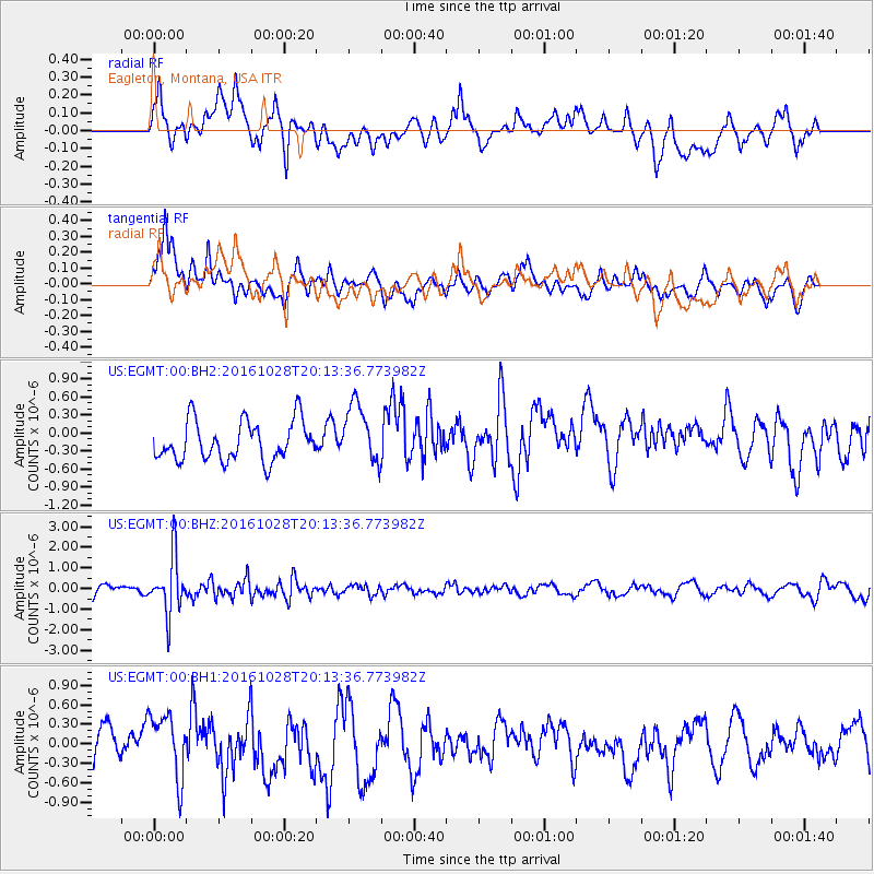
EGMT Eagleton, Montana, USA - Earthquake Result Viewer
*The percent match for this event was below the threshold and hence no stack was calculated.
| Earthquake location: |
Tyrrhenian Sea |
| Earthquake latitude/longitude: |
39.3/13.5 |
| Earthquake time(UTC): |
2016/10/28 (302) 20:02:48 GMT |
| Earthquake Depth: |
448 km |
| Earthquake Magnitude: |
5.8 MWW, 5.8 MWB |
| Earthquake Catalog/Contributor: |
NEIC PDE/NEIC COMCAT |
|
| Network: |
US United States National Seismic Network |
| Station: |
EGMT Eagleton, Montana, USA |
| Lat/Lon: |
48.02 N/109.75 W |
| Elevation: |
1055 m |
|
| Distance: |
79.5 deg |
| Az: |
325.204 deg |
| Baz: |
41.259 deg |
| Ray Param: |
$rayparam |
*The percent match for this event was below the threshold and hence was not used in the summary stack. |
|
| Radial Match: |
49.032116 % |
| Radial Bump: |
400 |
| Transverse Match: |
65.88957 % |
| Transverse Bump: |
400 |
| SOD ConfigId: |
1815711 |
| Insert Time: |
2016-11-11 20:12:14.409 +0000 |
| GWidth: |
2.5 |
| Max Bumps: |
400 |
| Tol: |
0.001 |
|
Signal To Noise
| Channel | StoN | STA | LTA |
| US:EGMT:00:BHZ:20161028T20:13:36.773982Z | 4.874958 | 1.3891049E-6 | 2.8494708E-7 |
| US:EGMT:00:BH1:20161028T20:13:36.773982Z | 2.7048447 | 4.9615113E-7 | 1.8343054E-7 |
| US:EGMT:00:BH2:20161028T20:13:36.773982Z | 1.5381908 | 5.0167125E-7 | 3.2614372E-7 |
| Arrivals |
| Ps | |
| PpPs | |
| PsPs/PpSs | |


