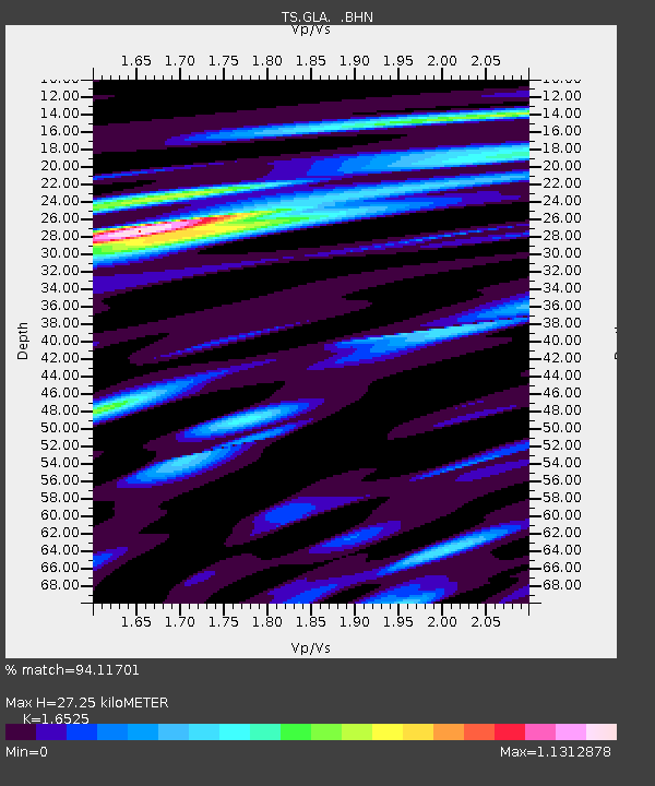
GLA Glamis, California, USA - Earthquake Result Viewer

Earthquake location: Unimak Island Region, Alaska
Earthquake latitude/longitude: 53.6/-163.5
Earthquake time(UTC): 1995/07/08 (189) 17:15:28 GMT
Earthquake Depth: 33 km
Earthquake Magnitude: 5.8 MB, 5.7 MS, 5.5 UNKNOWN, 6.0 MW
Earthquake Catalog/Contributor: WHDF/NEIC
Network: TS TERRAscope (Southern California Seismic Network)
Station: GLA Glamis, California, USA
Lat/Lon: 33.05 N/114.83 W
Elevation: 627 m
Distance: 40.0 deg
Az: 100.942 deg
Baz: 315.893 deg
Ray Param: 0.07458147
Estimated Moho Depth: 27.25 km
Estimated Crust Vp/Vs: 1.65
Assumed Crust Vp: 6.155 km/s
Estimated Crust Vs: 3.724 km/s
Estimated Crust Poisson's Ratio: 0.21
Radial Match: 94.11701 %
Radial Bump: 361
Transverse Match: 82.5298 %
Transverse Bump: 400
SOD ConfigId: 6273
Insert Time: 2010-02-26 14:12:14.106 +0000
GWidth: 2.5
Max Bumps: 400
Tol: 0.001

Signal To Noise

ChannelStoNSTALTA
TS:GLA: :BHN:19950708T17:22:29.274011Z2.14449791.3480384E-76.286033E-8
TS:GLA: :BHE:19950708T17:22:29.274011Z2.6181451.3788161E-75.266386E-8
TS:GLA: :BHZ:19950708T17:22:29.274011Z6.21258073.6131425E-75.815848E-8
Arrivals
Ps3.1 SECOND
PpPs11 SECOND
PsPs/PpSs14 SECOND