You are here: Home > Network List > TA - USArray Transportable Network (new EarthScope stations) Stations List
> Station D16A Dana Ranch, Cascade, MT, USA > Earthquake Result Viewer
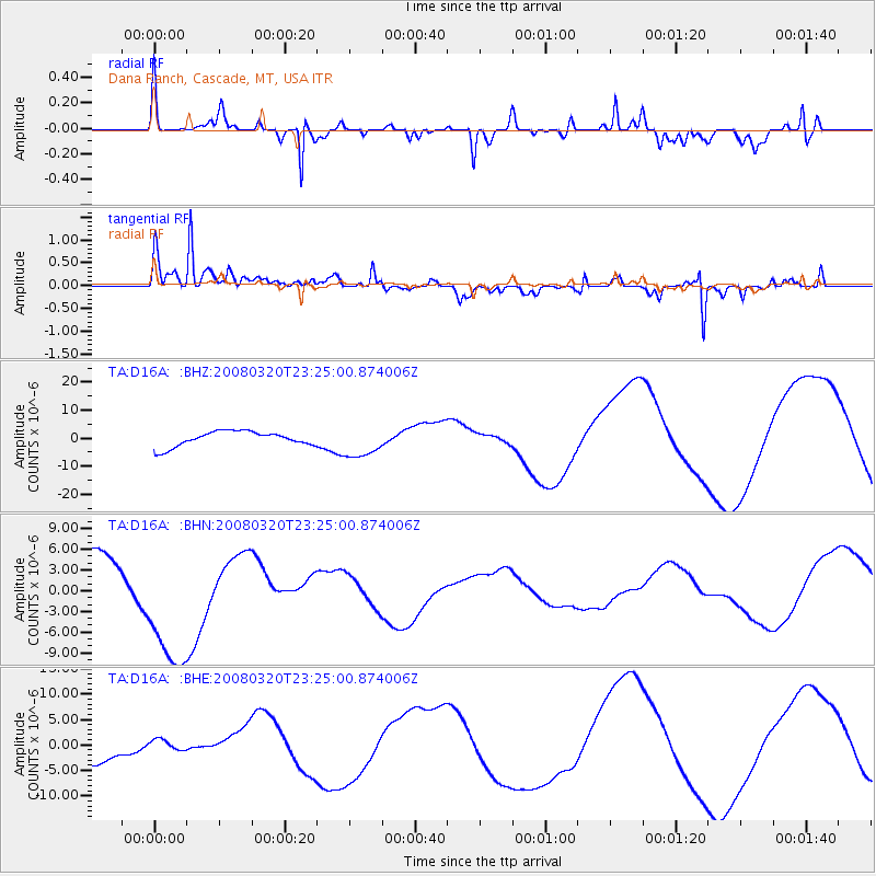
D16A Dana Ranch, Cascade, MT, USA - Earthquake Result Viewer
*The percent match for this event was below the threshold and hence no stack was calculated.
| Earthquake location: |
Southern Xinjiang, China |
| Earthquake latitude/longitude: |
35.5/81.4 |
| Earthquake time(UTC): |
2008/03/20 (080) 23:12:00 GMT |
| Earthquake Depth: |
10 km |
| Earthquake Magnitude: |
5.6 MB |
| Earthquake Catalog/Contributor: |
WHDF/NEIC |
|
| Network: |
TA USArray Transportable Network (new EarthScope stations) |
| Station: |
D16A Dana Ranch, Cascade, MT, USA |
| Lat/Lon: |
47.03 N/111.55 W |
| Elevation: |
1427 m |
|
| Distance: |
97.0 deg |
| Az: |
8.907 deg |
| Baz: |
349.359 deg |
| Ray Param: |
$rayparam |
*The percent match for this event was below the threshold and hence was not used in the summary stack. |
|
| Radial Match: |
79.68452 % |
| Radial Bump: |
329 |
| Transverse Match: |
59.906387 % |
| Transverse Bump: |
303 |
| SOD ConfigId: |
2504 |
| Insert Time: |
2010-03-06 22:19:56.785 +0000 |
| GWidth: |
2.5 |
| Max Bumps: |
400 |
| Tol: |
0.001 |
|
Signal To Noise
| Channel | StoN | STA | LTA |
| TA:D16A: :BHN:20080320T23:25:00.874006Z | 2.595836 | 9.8495E-6 | 3.7943462E-6 |
| TA:D16A: :BHE:20080320T23:25:00.874006Z | 0.3862117 | 1.5376008E-6 | 3.9812385E-6 |
| TA:D16A: :BHZ:20080320T23:25:00.874006Z | 2.146828 | 5.761897E-6 | 2.6839118E-6 |
| Arrivals |
| Ps | |
| PpPs | |
| PsPs/PpSs | |


