You are here: Home > Network List > TA - USArray Transportable Network (new EarthScope stations) Stations List
> Station D16A Dana Ranch, Cascade, MT, USA > Earthquake Result Viewer
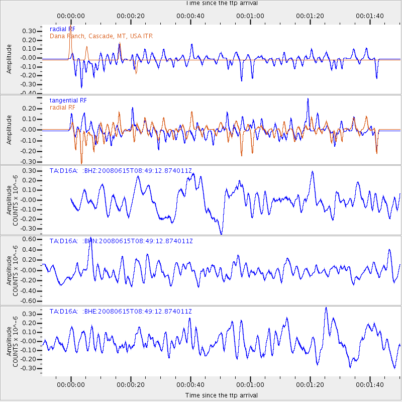
D16A Dana Ranch, Cascade, MT, USA - Earthquake Result Viewer
*The percent match for this event was below the threshold and hence no stack was calculated.
| Earthquake location: |
Southern East Pacific Rise |
| Earthquake latitude/longitude: |
-36.6/-107.4 |
| Earthquake time(UTC): |
2008/06/15 (167) 08:37:17 GMT |
| Earthquake Depth: |
10 km |
| Earthquake Magnitude: |
5.5 MB, 5.4 MS, 6.0 MW, 6.0 MW |
| Earthquake Catalog/Contributor: |
WHDF/NEIC |
|
| Network: |
TA USArray Transportable Network (new EarthScope stations) |
| Station: |
D16A Dana Ranch, Cascade, MT, USA |
| Lat/Lon: |
47.03 N/111.55 W |
| Elevation: |
1427 m |
|
| Distance: |
83.4 deg |
| Az: |
357.178 deg |
| Baz: |
176.681 deg |
| Ray Param: |
$rayparam |
*The percent match for this event was below the threshold and hence was not used in the summary stack. |
|
| Radial Match: |
57.04356 % |
| Radial Bump: |
352 |
| Transverse Match: |
65.53323 % |
| Transverse Bump: |
371 |
| SOD ConfigId: |
2504 |
| Insert Time: |
2010-03-06 22:20:13.916 +0000 |
| GWidth: |
2.5 |
| Max Bumps: |
400 |
| Tol: |
0.001 |
|
Signal To Noise
| Channel | StoN | STA | LTA |
| TA:D16A: :BHN:20080615T08:49:12.874011Z | 0.8509271 | 1.03021144E-7 | 1.2106929E-7 |
| TA:D16A: :BHE:20080615T08:49:12.874011Z | 1.1571563 | 9.491563E-8 | 8.202489E-8 |
| TA:D16A: :BHZ:20080615T08:49:12.874011Z | 1.9408767 | 1.8983333E-7 | 9.7808034E-8 |
| Arrivals |
| Ps | |
| PpPs | |
| PsPs/PpSs | |


