You are here: Home > Network List > TS - TERRAscope (Southern California Seismic Network) Stations List
> Station GLA Glamis, California, USA > Earthquake Result Viewer
GLA Glamis, California, USA - Earthquake Result Viewer

| Earthquake location: |
Caribbean Sea |
| Earthquake latitude/longitude: |
18.8/-81.7 |
| Earthquake time(UTC): |
1995/06/27 (178) 10:09:58 GMT |
| Earthquake Depth: |
10 km |
| Earthquake Magnitude: |
5.7 MB, 5.6 MS, 6.2 UNKNOWN, 6.1 MW |
| Earthquake Catalog/Contributor: |
WHDF/NEIC |
|
| Network: |
TS TERRAscope (Southern California Seismic Network) |
| Station: |
GLA Glamis, California, USA |
| Lat/Lon: |
33.05 N/114.83 W |
| Elevation: |
627 m |
|
| Distance: |
32.8 deg |
| Az: |
302.143 deg |
| Baz: |
107.292 deg |
| Ray Param: |
0.0785003 |
| Estimated Moho Depth: |
31.25 km |
| Estimated Crust Vp/Vs: |
1.61 |
| Assumed Crust Vp: |
6.155 km/s |
| Estimated Crust Vs: |
3.823 km/s |
| Estimated Crust Poisson's Ratio: |
0.19 |
|
| Radial Match: |
89.23374 % |
| Radial Bump: |
223 |
| Transverse Match: |
77.144196 % |
| Transverse Bump: |
400 |
| SOD ConfigId: |
6273 |
| Insert Time: |
2010-02-26 14:12:18.087 +0000 |
| GWidth: |
2.5 |
| Max Bumps: |
400 |
| Tol: |
0.001 |
|
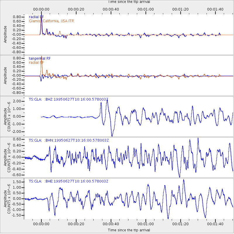
Signal To Noise
| Channel | StoN | STA | LTA |
| TS:GLA: :BHN:19950627T10:16:00.578003Z | 2.7686496 | 1.07761146E-7 | 3.8921915E-8 |
| TS:GLA: :BHE:19950627T10:16:00.578003Z | 4.1435733 | 3.2248053E-7 | 7.782668E-8 |
| TS:GLA: :BHZ:19950627T10:16:00.578003Z | 10.934117 | 6.376301E-7 | 5.8315642E-8 |
| Arrivals |
| Ps | 3.4 SECOND |
| PpPs | 12 SECOND |
| PsPs/PpSs | 16 SECOND |


