You are here: Home > Network List > TA - USArray Transportable Network (new EarthScope stations) Stations List
> Station D16A Dana Ranch, Cascade, MT, USA > Earthquake Result Viewer
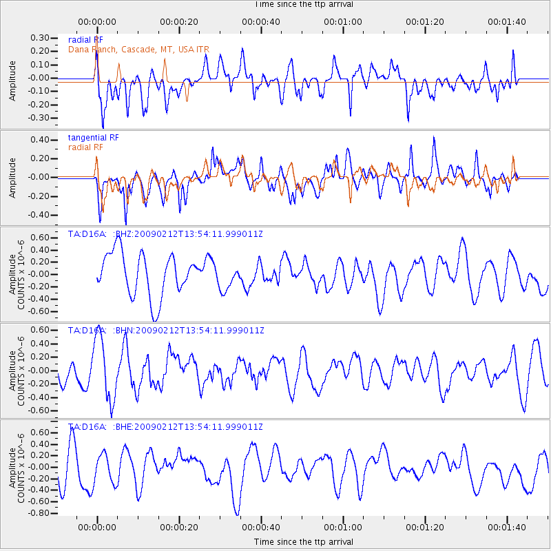
D16A Dana Ranch, Cascade, MT, USA - Earthquake Result Viewer
*The percent match for this event was below the threshold and hence no stack was calculated.
| Earthquake location: |
South Of Mariana Islands |
| Earthquake latitude/longitude: |
12.1/143.8 |
| Earthquake time(UTC): |
2009/02/12 (043) 13:41:43 GMT |
| Earthquake Depth: |
40 km |
| Earthquake Magnitude: |
5.5 MB |
| Earthquake Catalog/Contributor: |
WHDF/NEIC |
|
| Network: |
TA USArray Transportable Network (new EarthScope stations) |
| Station: |
D16A Dana Ranch, Cascade, MT, USA |
| Lat/Lon: |
47.03 N/111.55 W |
| Elevation: |
1427 m |
|
| Distance: |
91.0 deg |
| Az: |
41.438 deg |
| Baz: |
288.898 deg |
| Ray Param: |
$rayparam |
*The percent match for this event was below the threshold and hence was not used in the summary stack. |
|
| Radial Match: |
50.974392 % |
| Radial Bump: |
400 |
| Transverse Match: |
62.034203 % |
| Transverse Bump: |
400 |
| SOD ConfigId: |
2658 |
| Insert Time: |
2010-03-06 22:20:23.268 +0000 |
| GWidth: |
2.5 |
| Max Bumps: |
400 |
| Tol: |
0.001 |
|
Signal To Noise
| Channel | StoN | STA | LTA |
| TA:D16A: :BHN:20090212T13:54:11.999011Z | 2.6744523 | 4.787536E-7 | 1.7900994E-7 |
| TA:D16A: :BHE:20090212T13:54:11.999011Z | 0.78952646 | 2.5080973E-7 | 3.1767107E-7 |
| TA:D16A: :BHZ:20090212T13:54:11.999011Z | 0.58554935 | 2.060762E-7 | 3.5193648E-7 |
| Arrivals |
| Ps | |
| PpPs | |
| PsPs/PpSs | |


