You are here: Home > Network List > US - United States National Seismic Network Stations List
> Station WUAZ Wupatki, Arizona, USA > Earthquake Result Viewer
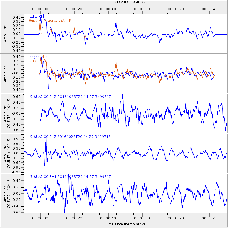
WUAZ Wupatki, Arizona, USA - Earthquake Result Viewer
*The percent match for this event was below the threshold and hence no stack was calculated.
| Earthquake location: |
Tyrrhenian Sea |
| Earthquake latitude/longitude: |
39.3/13.5 |
| Earthquake time(UTC): |
2016/10/28 (302) 20:02:48 GMT |
| Earthquake Depth: |
448 km |
| Earthquake Magnitude: |
5.8 MWW, 5.8 MWB |
| Earthquake Catalog/Contributor: |
NEIC PDE/NEIC COMCAT |
|
| Network: |
US United States National Seismic Network |
| Station: |
WUAZ Wupatki, Arizona, USA |
| Lat/Lon: |
35.52 N/111.37 W |
| Elevation: |
1592 m |
|
| Distance: |
89.8 deg |
| Az: |
318.011 deg |
| Baz: |
39.507 deg |
| Ray Param: |
$rayparam |
*The percent match for this event was below the threshold and hence was not used in the summary stack. |
|
| Radial Match: |
61.64021 % |
| Radial Bump: |
400 |
| Transverse Match: |
74.78644 % |
| Transverse Bump: |
400 |
| SOD ConfigId: |
1815711 |
| Insert Time: |
2016-11-11 20:13:17.840 +0000 |
| GWidth: |
2.5 |
| Max Bumps: |
400 |
| Tol: |
0.001 |
|
Signal To Noise
| Channel | StoN | STA | LTA |
| US:WUAZ:00:BHZ:20161028T20:14:27.349971Z | 2.2839553 | 3.975189E-7 | 1.7404845E-7 |
| US:WUAZ:00:BH1:20161028T20:14:27.349971Z | 1.2764664 | 1.6458561E-7 | 1.2893847E-7 |
| US:WUAZ:00:BH2:20161028T20:14:27.349971Z | 1.234989 | 2.1458544E-7 | 1.7375494E-7 |
| Arrivals |
| Ps | |
| PpPs | |
| PsPs/PpSs | |


