You are here: Home > Network List > TS - TERRAscope (Southern California Seismic Network) Stations List
> Station GLA Glamis, California, USA > Earthquake Result Viewer
GLA Glamis, California, USA - Earthquake Result Viewer
| Earthquake location: |
Southeast Of Loyalty Islands |
| Earthquake latitude/longitude: |
-23.0/169.9 |
| Earthquake time(UTC): |
1995/05/16 (136) 20:12:45 GMT |
| Earthquake Depth: |
33 km |
| Earthquake Magnitude: |
6.8 MB, 7.7 MS, 7.7 UNKNOWN, 7.7 MW |
| Earthquake Catalog/Contributor: |
WHDF/NEIC |
|
| Network: |
TS TERRAscope (Southern California Seismic Network) |
| Station: |
GLA Glamis, California, USA |
| Lat/Lon: |
33.05 N/114.83 W |
| Elevation: |
627 m |
|
| Distance: |
90.8 deg |
| Az: |
54.328 deg |
| Baz: |
243.025 deg |
| Ray Param: |
0.041641798 |
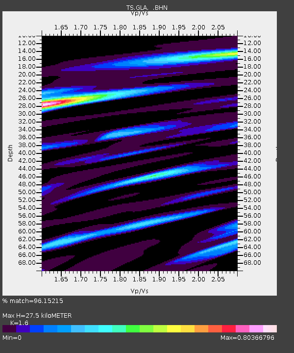
| Estimated Moho Depth: |
27.5 km |
| Estimated Crust Vp/Vs: |
1.60 |
| Assumed Crust Vp: |
6.155 km/s |
| Estimated Crust Vs: |
3.847 km/s |
| Estimated Crust Poisson's Ratio: |
0.18 |
|
| Radial Match: |
96.15215 % |
| Radial Bump: |
400 |
| Transverse Match: |
92.178665 % |
| Transverse Bump: |
400 |
| SOD ConfigId: |
6273 |
| Insert Time: |
2010-02-26 14:12:20.036 +0000 |
| GWidth: |
2.5 |
| Max Bumps: |
400 |
| Tol: |
0.001 |
|
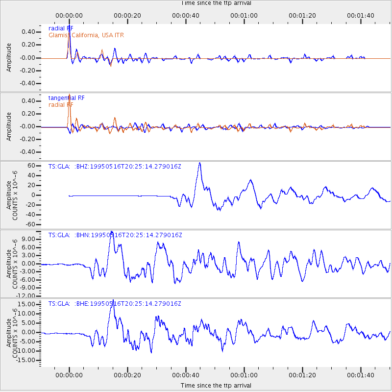
Signal To Noise
| Channel | StoN | STA | LTA |
| TS:GLA: :BHN:19950516T20:25:14.279016Z | 1.5182843 | 1.5803124E-7 | 1.0408541E-7 |
| TS:GLA: :BHE:19950516T20:25:14.279016Z | 1.1461565 | 1.5012499E-7 | 1.3098122E-7 |
| TS:GLA: :BHZ:19950516T20:25:14.279016Z | 6.6903477 | 6.070522E-7 | 9.0735526E-8 |
| Arrivals |
| Ps | 2.7 SECOND |
| PpPs | 11 SECOND |
| PsPs/PpSs | 14 SECOND |


