You are here: Home > Network List > TA - USArray Transportable Network (new EarthScope stations) Stations List
> Station H17A Grant Village (NPS), Yellowstone Nt. Park, WY, USA > Earthquake Result Viewer
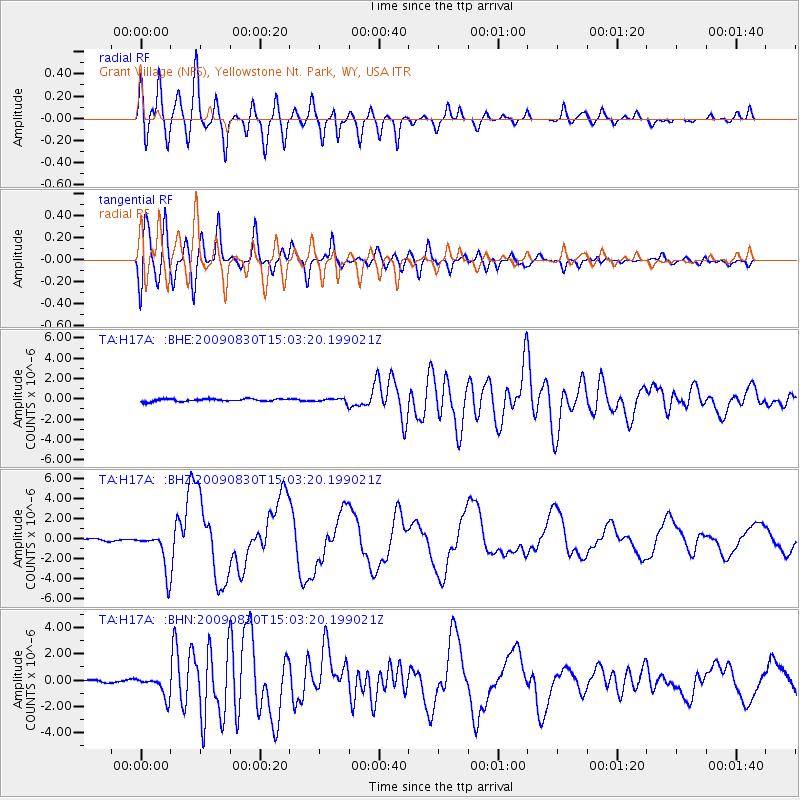
H17A Grant Village (NPS), Yellowstone Nt. Park, WY, USA - Earthquake Result Viewer
*The percent match for this event was below the threshold and hence no stack was calculated.
| Earthquake location: |
Samoa Islands Region |
| Earthquake latitude/longitude: |
-15.2/-172.6 |
| Earthquake time(UTC): |
2009/08/30 (242) 14:51:32 GMT |
| Earthquake Depth: |
11 km |
| Earthquake Magnitude: |
6.4 MB, 6.3 MS, 6.6 MW, 6.6 MW |
| Earthquake Catalog/Contributor: |
WHDF/NEIC |
|
| Network: |
TA USArray Transportable Network (new EarthScope stations) |
| Station: |
H17A Grant Village (NPS), Yellowstone Nt. Park, WY, USA |
| Lat/Lon: |
44.40 N/110.58 W |
| Elevation: |
2400 m |
|
| Distance: |
81.8 deg |
| Az: |
39.755 deg |
| Baz: |
239.448 deg |
| Ray Param: |
$rayparam |
*The percent match for this event was below the threshold and hence was not used in the summary stack. |
|
| Radial Match: |
92.661476 % |
| Radial Bump: |
400 |
| Transverse Match: |
91.89281 % |
| Transverse Bump: |
400 |
| SOD ConfigId: |
2622 |
| Insert Time: |
2010-03-06 22:21:20.064 +0000 |
| GWidth: |
2.5 |
| Max Bumps: |
400 |
| Tol: |
0.001 |
|
Signal To Noise
| Channel | StoN | STA | LTA |
| TA:H17A: :BHZ:20090830T15:03:20.199021Z | 18.430885 | 1.9615732E-6 | 1.0642859E-7 |
| TA:H17A: :BHN:20090830T15:03:20.199021Z | 7.430552 | 8.0406204E-7 | 1.0821027E-7 |
| TA:H17A: :BHE:20090830T15:03:20.199021Z | 1.667987 | 2.0779571E-7 | 1.2457873E-7 |
| Arrivals |
| Ps | |
| PpPs | |
| PsPs/PpSs | |


