You are here: Home > Network List > TA - USArray Transportable Network (new EarthScope stations) Stations List
> Station H17A Grant Village (NPS), Yellowstone Nt. Park, WY, USA > Earthquake Result Viewer
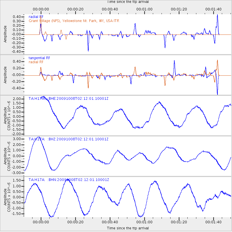
H17A Grant Village (NPS), Yellowstone Nt. Park, WY, USA - Earthquake Result Viewer
*The percent match for this event was below the threshold and hence no stack was calculated.
| Earthquake location: |
Santa Cruz Islands |
| Earthquake latitude/longitude: |
-11.9/166.0 |
| Earthquake time(UTC): |
2009/10/08 (281) 01:59:19 GMT |
| Earthquake Depth: |
35 km |
| Earthquake Magnitude: |
5.9 MB |
| Earthquake Catalog/Contributor: |
WHDF/NEIC |
|
| Network: |
TA USArray Transportable Network (new EarthScope stations) |
| Station: |
H17A Grant Village (NPS), Yellowstone Nt. Park, WY, USA |
| Lat/Lon: |
44.40 N/110.58 W |
| Elevation: |
2400 m |
|
| Distance: |
93.6 deg |
| Az: |
45.531 deg |
| Baz: |
256.998 deg |
| Ray Param: |
$rayparam |
*The percent match for this event was below the threshold and hence was not used in the summary stack. |
|
| Radial Match: |
68.27149 % |
| Radial Bump: |
400 |
| Transverse Match: |
75.93731 % |
| Transverse Bump: |
331 |
| SOD ConfigId: |
2622 |
| Insert Time: |
2010-03-06 22:21:27.461 +0000 |
| GWidth: |
2.5 |
| Max Bumps: |
400 |
| Tol: |
0.001 |
|
Signal To Noise
| Channel | StoN | STA | LTA |
| TA:H17A: :BHZ:20091008T02:12:01.10001Z | 1.3759224 | 2.053702E-6 | 1.4926002E-6 |
| TA:H17A: :BHN:20091008T02:12:01.10001Z | 1.193347 | 9.0487185E-7 | 7.5826387E-7 |
| TA:H17A: :BHE:20091008T02:12:01.10001Z | 1.0803764 | 1.2069523E-6 | 1.1171591E-6 |
| Arrivals |
| Ps | |
| PpPs | |
| PsPs/PpSs | |


