You are here: Home > Network List > TS - TERRAscope (Southern California Seismic Network) Stations List
> Station GLA Glamis, California, USA > Earthquake Result Viewer
GLA Glamis, California, USA - Earthquake Result Viewer
| Earthquake location: |
Leeward Islands |
| Earthquake latitude/longitude: |
16.6/-59.6 |
| Earthquake time(UTC): |
1995/03/08 (067) 03:45:59 GMT |
| Earthquake Depth: |
15 km |
| Earthquake Magnitude: |
6.3 MB, 6.2 MS, 6.4 UNKNOWN, 6.1 MD |
| Earthquake Catalog/Contributor: |
WHDF/NEIC |
|
| Network: |
TS TERRAscope (Southern California Seismic Network) |
| Station: |
GLA Glamis, California, USA |
| Lat/Lon: |
33.05 N/114.83 W |
| Elevation: |
627 m |
|
| Distance: |
52.2 deg |
| Az: |
299.161 deg |
| Baz: |
94.274 deg |
| Ray Param: |
0.066894464 |
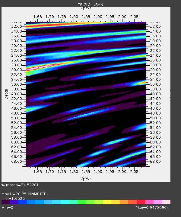
| Estimated Moho Depth: |
28.75 km |
| Estimated Crust Vp/Vs: |
1.65 |
| Assumed Crust Vp: |
6.155 km/s |
| Estimated Crust Vs: |
3.724 km/s |
| Estimated Crust Poisson's Ratio: |
0.21 |
|
| Radial Match: |
91.52281 % |
| Radial Bump: |
400 |
| Transverse Match: |
86.401085 % |
| Transverse Bump: |
400 |
| SOD ConfigId: |
6273 |
| Insert Time: |
2010-02-26 14:12:24.002 +0000 |
| GWidth: |
2.5 |
| Max Bumps: |
400 |
| Tol: |
0.001 |
|

Signal To Noise
| Channel | StoN | STA | LTA |
| TS:GLA: :BHN:19950308T03:54:38.882007Z | 0.74361765 | 1.4286196E-7 | 1.921175E-7 |
| TS:GLA: :BHE:19950308T03:54:38.882007Z | 1.6693283 | 3.4683347E-7 | 2.0776828E-7 |
| TS:GLA: :BHZ:19950308T03:54:38.882007Z | 3.1399198 | 6.9977057E-7 | 2.2286257E-7 |
| Arrivals |
| Ps | 3.2 SECOND |
| PpPs | 12 SECOND |
| PsPs/PpSs | 15 SECOND |


