You are here: Home > Network List > CI - Caltech Regional Seismic Network Stations List
> Station DAN Danby, California, USA > Earthquake Result Viewer
DAN Danby, California, USA - Earthquake Result Viewer
| Earthquake location: |
Panama-Costa Rica Border Region |
| Earthquake latitude/longitude: |
8.6/-82.8 |
| Earthquake time(UTC): |
2019/05/12 (132) 19:24:50 GMT |
| Earthquake Depth: |
19 km |
| Earthquake Magnitude: |
6.1 Mww |
| Earthquake Catalog/Contributor: |
NEIC PDE/us |
|
| Network: |
CI Caltech Regional Seismic Network |
| Station: |
DAN Danby, California, USA |
| Lat/Lon: |
34.64 N/115.38 W |
| Elevation: |
398 m |
|
| Distance: |
39.5 deg |
| Az: |
315.802 deg |
| Baz: |
123.272 deg |
| Ray Param: |
0.07491952 |
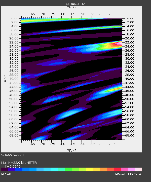
| Estimated Moho Depth: |
22.0 km |
| Estimated Crust Vp/Vs: |
2.10 |
| Assumed Crust Vp: |
6.276 km/s |
| Estimated Crust Vs: |
2.992 km/s |
| Estimated Crust Poisson's Ratio: |
0.35 |
|
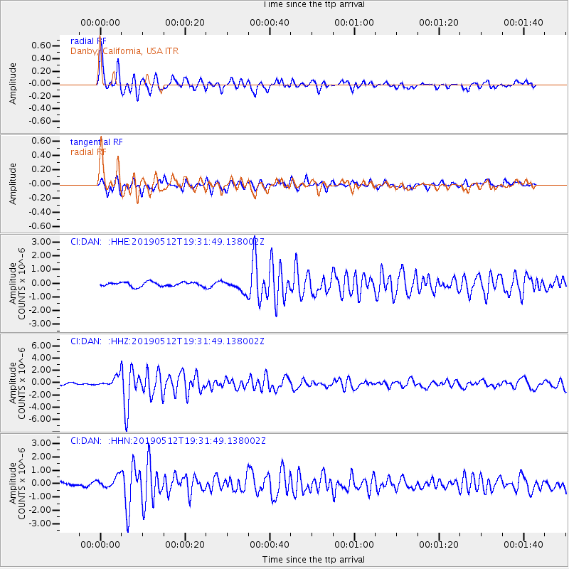
| Radial Match: |
92.15355 % |
| Radial Bump: |
400 |
| Transverse Match: |
84.83525 % |
| Transverse Bump: |
400 |
| SOD ConfigId: |
18369291 |
| Insert Time: |
2019-05-26 19:27:11.564 +0000 |
| GWidth: |
2.5 |
| Max Bumps: |
400 |
| Tol: |
0.001 |
|
Signal To Noise
| Channel | StoN | STA | LTA |
| CI:DAN: :HHZ:20190512T19:31:49.138002Z | 5.9446363 | 9.0959946E-7 | 1.530118E-7 |
| CI:DAN: :HHN:20190512T19:31:49.138002Z | 2.605446 | 4.1799854E-7 | 1.6043262E-7 |
| CI:DAN: :HHE:20190512T19:31:49.138002Z | 2.8074808 | 4.2934548E-7 | 1.5292908E-7 |
| Arrivals |
| Ps | 4.1 SECOND |
| PpPs | 10 SECOND |
| PsPs/PpSs | 14 SECOND |


