You are here: Home > Network List > CI - Caltech Regional Seismic Network Stations List
> Station TIN Tinemaha, Big Pine, CA, USA > Earthquake Result Viewer
TIN Tinemaha, Big Pine, CA, USA - Earthquake Result Viewer
| Earthquake location: |
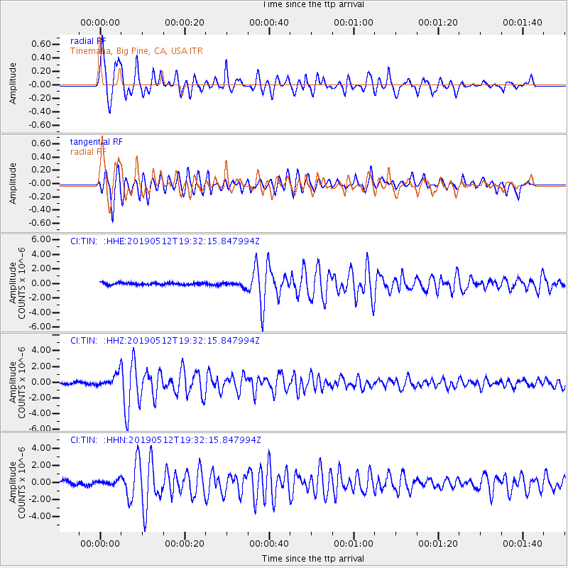
Panama-Costa Rica Border Region |
| Earthquake latitude/longitude: |
8.6/-82.8 |
| Earthquake time(UTC): |
2019/05/12 (132) 19:24:50 GMT |
| Earthquake Depth: |
19 km |
| Earthquake Magnitude: |
6.1 Mww |
| Earthquake Catalog/Contributor: |
NEIC PDE/us |
|
| Network: |
CI Caltech Regional Seismic Network |
| Station: |
TIN Tinemaha, Big Pine, CA, USA |
| Lat/Lon: |
37.05 N/118.23 W |
| Elevation: |
1197 m |
|
| Distance: |
42.8 deg |
| Az: |
316.97 deg |
| Baz: |
122.489 deg |
| Ray Param: |
0.07295621 |
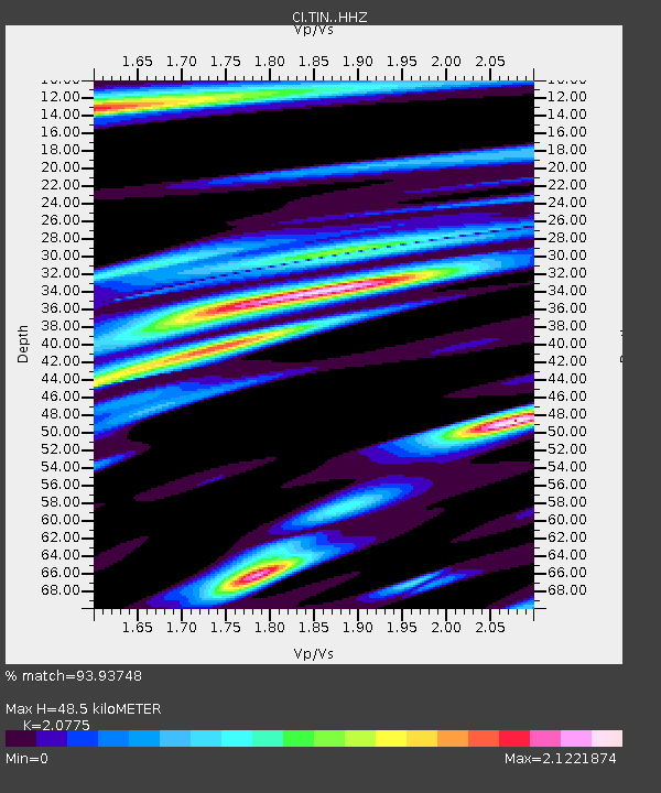
| Estimated Moho Depth: |
48.5 km |
| Estimated Crust Vp/Vs: |
2.08 |
| Assumed Crust Vp: |
6.291 km/s |
| Estimated Crust Vs: |
3.028 km/s |
| Estimated Crust Poisson's Ratio: |
0.35 |
|
| Radial Match: |
93.93748 % |
| Radial Bump: |
400 |
| Transverse Match: |
89.24929 % |
| Transverse Bump: |
400 |
| SOD ConfigId: |
18369291 |
| Insert Time: |
2019-05-26 19:27:38.635 +0000 |
| GWidth: |
2.5 |
| Max Bumps: |
400 |
| Tol: |
0.001 |
|
Signal To Noise
| Channel | StoN | STA | LTA |
| CI:TIN: :HHZ:20190512T19:32:15.847994Z | 6.230706 | 8.876978E-7 | 1.4247145E-7 |
| CI:TIN: :HHN:20190512T19:32:15.847994Z | 1.4478278 | 2.9286426E-7 | 2.0227837E-7 |
| CI:TIN: :HHE:20190512T19:32:15.847994Z | 2.3956888 | 3.5108891E-7 | 1.4655029E-7 |
| Arrivals |
| Ps | 8.8 SECOND |
| PpPs | 22 SECOND |
| PsPs/PpSs | 31 SECOND |


