You are here: Home > Network List > TS - TERRAscope (Southern California Seismic Network) Stations List
> Station GLA Glamis, California, USA > Earthquake Result Viewer
GLA Glamis, California, USA - Earthquake Result Viewer

| Earthquake location: |
New Ireland Region, P.N.G. |
| Earthquake latitude/longitude: |
-4.0/153.9 |
| Earthquake time(UTC): |
1995/06/24 (175) 06:58:06 GMT |
| Earthquake Depth: |
386 km |
| Earthquake Magnitude: |
6.2 MB, 6.8 UNKNOWN |
| Earthquake Catalog/Contributor: |
WHDF/NEIC |
|
| Network: |
TS TERRAscope (Southern California Seismic Network) |
| Station: |
GLA Glamis, California, USA |
| Lat/Lon: |
33.05 N/114.83 W |
| Elevation: |
627 m |
|
| Distance: |
93.2 deg |
| Az: |
57.24 deg |
| Baz: |
267.343 deg |
| Ray Param: |
0.04103425 |
| Estimated Moho Depth: |
26.5 km |
| Estimated Crust Vp/Vs: |
1.65 |
| Assumed Crust Vp: |
6.155 km/s |
| Estimated Crust Vs: |
3.719 km/s |
| Estimated Crust Poisson's Ratio: |
0.21 |
|
| Radial Match: |
88.630066 % |
| Radial Bump: |
400 |
| Transverse Match: |
74.58272 % |
| Transverse Bump: |
400 |
| SOD ConfigId: |
6273 |
| Insert Time: |
2010-02-26 14:12:31.555 +0000 |
| GWidth: |
2.5 |
| Max Bumps: |
400 |
| Tol: |
0.001 |
|
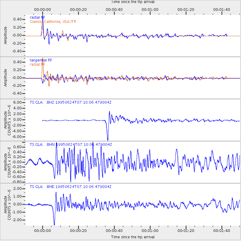
Signal To Noise
| Channel | StoN | STA | LTA |
| TS:GLA: :BHN:19950624T07:10:06.479004Z | 0.90082276 | 6.073863E-8 | 6.7425724E-8 |
| TS:GLA: :BHE:19950624T07:10:06.479004Z | 0.54127914 | 3.646546E-8 | 6.736905E-8 |
| TS:GLA: :BHZ:19950624T07:10:06.479004Z | 0.8389285 | 6.554474E-8 | 7.812911E-8 |
| Arrivals |
| Ps | 2.9 SECOND |
| PpPs | 11 SECOND |
| PsPs/PpSs | 14 SECOND |


