You are here: Home > Network List > G - GEOSCOPE Stations List
> Station MPG Montagne des Peres, French Guyana > Earthquake Result Viewer
MPG Montagne des Peres, French Guyana - Earthquake Result Viewer
| Earthquake location: |
Panama-Costa Rica Border Region |
| Earthquake latitude/longitude: |
8.6/-82.8 |
| Earthquake time(UTC): |
2019/05/12 (132) 19:24:50 GMT |
| Earthquake Depth: |
19 km |
| Earthquake Magnitude: |
6.1 Mww |
| Earthquake Catalog/Contributor: |
NEIC PDE/us |
|
| Network: |
G GEOSCOPE |
| Station: |
MPG Montagne des Peres, French Guyana |
| Lat/Lon: |
5.11 N/52.64 W |
| Elevation: |
147 m |
|
| Distance: |
30.2 deg |
| Az: |
94.626 deg |
| Baz: |
278.295 deg |
| Ray Param: |
0.079390734 |
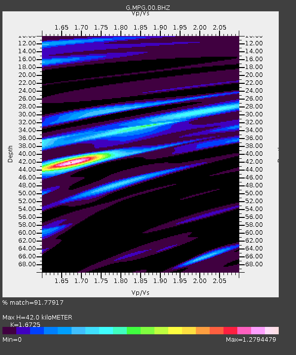
| Estimated Moho Depth: |
42.0 km |
| Estimated Crust Vp/Vs: |
1.67 |
| Assumed Crust Vp: |
6.472 km/s |
| Estimated Crust Vs: |
3.87 km/s |
| Estimated Crust Poisson's Ratio: |
0.22 |
|
| Radial Match: |
91.77917 % |
| Radial Bump: |
335 |
| Transverse Match: |
72.432945 % |
| Transverse Bump: |
400 |
| SOD ConfigId: |
18369291 |
| Insert Time: |
2019-05-26 19:28:39.256 +0000 |
| GWidth: |
2.5 |
| Max Bumps: |
400 |
| Tol: |
0.001 |
|

Signal To Noise
| Channel | StoN | STA | LTA |
| G:MPG:00:BHZ:20190512T19:30:28.850008Z | 3.0315268 | 6.1727553E-7 | 2.0361871E-7 |
| G:MPG:00:BHN:20190512T19:30:28.850008Z | 1.010575 | 1.6365328E-7 | 1.6194076E-7 |
| G:MPG:00:BHE:20190512T19:30:28.850008Z | 2.4046865 | 3.8744992E-7 | 1.6112284E-7 |
| Arrivals |
| Ps | 4.8 SECOND |
| PpPs | 16 SECOND |
| PsPs/PpSs | 21 SECOND |


