You are here: Home > Network List > TA - USArray Transportable Network (new EarthScope stations) Stations List
> Station H17A Grant Village (NPS), Yellowstone Nt. Park, WY, USA > Earthquake Result Viewer
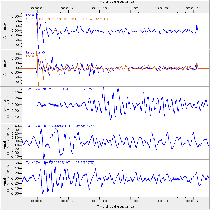
H17A Grant Village (NPS), Yellowstone Nt. Park, WY, USA - Earthquake Result Viewer
*The percent match for this event was below the threshold and hence no stack was calculated.
| Earthquake location: |
Easter Island Region |
| Earthquake latitude/longitude: |
-28.5/-112.8 |
| Earthquake time(UTC): |
2008/08/19 (232) 10:58:00 GMT |
| Earthquake Depth: |
9.0 km |
| Earthquake Magnitude: |
5.5 MB, 5.3 MS, 5.7 MW, 5.7 MW |
| Earthquake Catalog/Contributor: |
WHDF/NEIC |
|
| Network: |
TA USArray Transportable Network (new EarthScope stations) |
| Station: |
H17A Grant Village (NPS), Yellowstone Nt. Park, WY, USA |
| Lat/Lon: |
44.40 N/110.58 W |
| Elevation: |
2400 m |
|
| Distance: |
72.6 deg |
| Az: |
1.702 deg |
| Baz: |
182.089 deg |
| Ray Param: |
$rayparam |
*The percent match for this event was below the threshold and hence was not used in the summary stack. |
|
| Radial Match: |
78.630424 % |
| Radial Bump: |
400 |
| Transverse Match: |
85.529274 % |
| Transverse Bump: |
400 |
| SOD ConfigId: |
2504 |
| Insert Time: |
2010-03-06 22:23:07.968 +0000 |
| GWidth: |
2.5 |
| Max Bumps: |
400 |
| Tol: |
0.001 |
|
Signal To Noise
| Channel | StoN | STA | LTA |
| TA:H17A: :BHN:20080819T11:08:56.575Z | 5.8332043 | 2.290179E-7 | 3.926108E-8 |
| TA:H17A: :BHE:20080819T11:08:56.575Z | 3.5377727 | 2.8537886E-7 | 8.066625E-8 |
| TA:H17A: :BHZ:20080819T11:08:56.575Z | 2.5675783 | 1.0893672E-7 | 4.2427807E-8 |
| Arrivals |
| Ps | |
| PpPs | |
| PsPs/PpSs | |


