You are here: Home > Network List > IW - Intermountain West Stations List
> Station MOOW Moose Ponds, Wyoming, USA > Earthquake Result Viewer
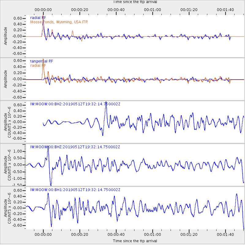
MOOW Moose Ponds, Wyoming, USA - Earthquake Result Viewer
*The percent match for this event was below the threshold and hence no stack was calculated.
| Earthquake location: |
Panama-Costa Rica Border Region |
| Earthquake latitude/longitude: |
8.6/-82.8 |
| Earthquake time(UTC): |
2019/05/12 (132) 19:24:50 GMT |
| Earthquake Depth: |
19 km |
| Earthquake Magnitude: |
6.1 Mww |
| Earthquake Catalog/Contributor: |
NEIC PDE/us |
|
| Network: |
IW Intermountain West |
| Station: |
MOOW Moose Ponds, Wyoming, USA |
| Lat/Lon: |
43.75 N/110.74 W |
| Elevation: |
2128 m |
|
| Distance: |
42.6 deg |
| Az: |
329.945 deg |
| Baz: |
136.889 deg |
| Ray Param: |
$rayparam |
*The percent match for this event was below the threshold and hence was not used in the summary stack. |
|
| Radial Match: |
77.71498 % |
| Radial Bump: |
313 |
| Transverse Match: |
61.069855 % |
| Transverse Bump: |
400 |
| SOD ConfigId: |
18369291 |
| Insert Time: |
2019-05-26 19:29:24.387 +0000 |
| GWidth: |
2.5 |
| Max Bumps: |
400 |
| Tol: |
0.001 |
|
Signal To Noise
| Channel | StoN | STA | LTA |
| IW:MOOW:00:BHZ:20190512T19:32:14.750002Z | 7.969313 | 7.789054E-7 | 9.773809E-8 |
| IW:MOOW:00:BH1:20190512T19:32:14.750002Z | 4.461401 | 2.7623696E-7 | 6.191709E-8 |
| IW:MOOW:00:BH2:20190512T19:32:14.750002Z | 6.430697 | 3.2479852E-7 | 5.0507516E-8 |
| Arrivals |
| Ps | |
| PpPs | |
| PsPs/PpSs | |


