You are here: Home > Network List > TS - TERRAscope (Southern California Seismic Network) Stations List
> Station GLA Glamis, California, USA > Earthquake Result Viewer
GLA Glamis, California, USA - Earthquake Result Viewer

| Earthquake location: |
Tonga Islands |
| Earthquake latitude/longitude: |
-21.1/-175.5 |
| Earthquake time(UTC): |
1995/07/28 (209) 14:29:12 GMT |
| Earthquake Depth: |
102 km |
| Earthquake Magnitude: |
6.1 MB, 6.5 UNKNOWN, 6.4 MW |
| Earthquake Catalog/Contributor: |
WHDF/NEIC |
|
| Network: |
TS TERRAscope (Southern California Seismic Network) |
| Station: |
GLA Glamis, California, USA |
| Lat/Lon: |
33.05 N/114.83 W |
| Elevation: |
627 m |
|
| Distance: |
79.0 deg |
| Az: |
48.218 deg |
| Baz: |
236.006 deg |
| Ray Param: |
0.0489992 |
| Estimated Moho Depth: |
26.75 km |
| Estimated Crust Vp/Vs: |
1.63 |
| Assumed Crust Vp: |
6.155 km/s |
| Estimated Crust Vs: |
3.77 km/s |
| Estimated Crust Poisson's Ratio: |
0.20 |
|
| Radial Match: |
97.125854 % |
| Radial Bump: |
400 |
| Transverse Match: |
92.668655 % |
| Transverse Bump: |
400 |
| SOD ConfigId: |
6273 |
| Insert Time: |
2010-02-26 14:12:36.593 +0000 |
| GWidth: |
2.5 |
| Max Bumps: |
400 |
| Tol: |
0.001 |
|
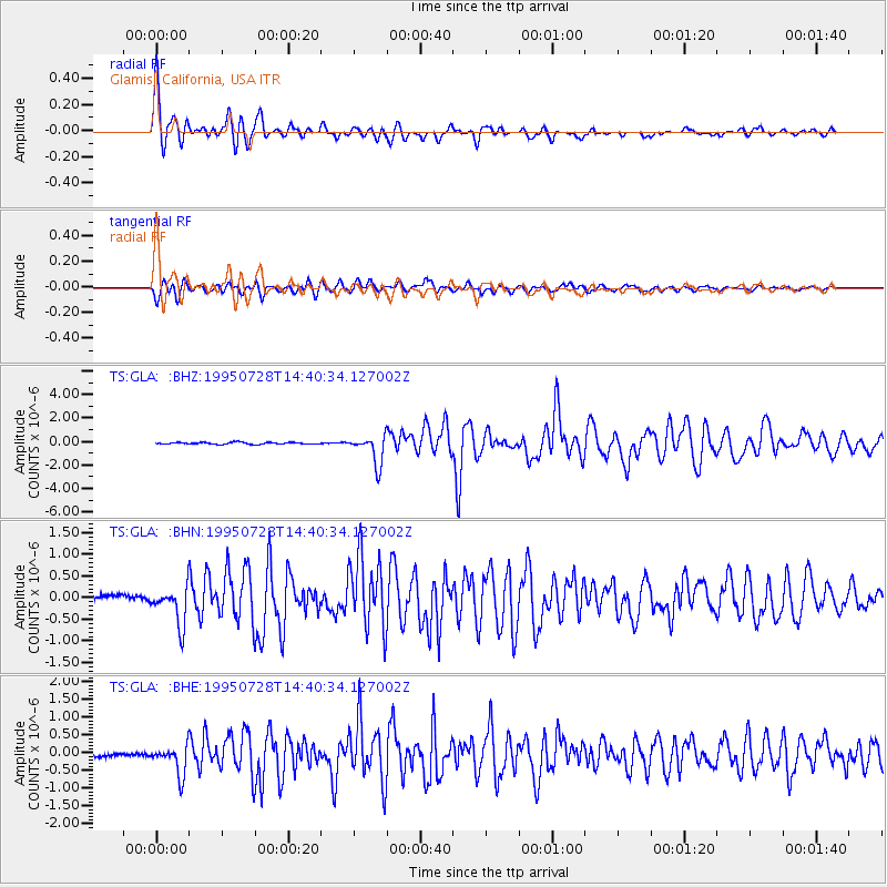
Signal To Noise
| Channel | StoN | STA | LTA |
| TS:GLA: :BHN:19950728T14:40:34.127002Z | 6.391197 | 4.4286205E-7 | 6.9292504E-8 |
| TS:GLA: :BHE:19950728T14:40:34.127002Z | 6.9002347 | 4.1159086E-7 | 5.964882E-8 |
| TS:GLA: :BHZ:19950728T14:40:34.127002Z | 15.558821 | 1.2285504E-6 | 7.896167E-8 |
| Arrivals |
| Ps | 2.8 SECOND |
| PpPs | 11 SECOND |
| PsPs/PpSs | 14 SECOND |


