You are here: Home > Network List > IU - Global Seismograph Network (GSN - IRIS/USGS) Stations List
> Station FURI Mt. Furi, Ethiopia > Earthquake Result Viewer
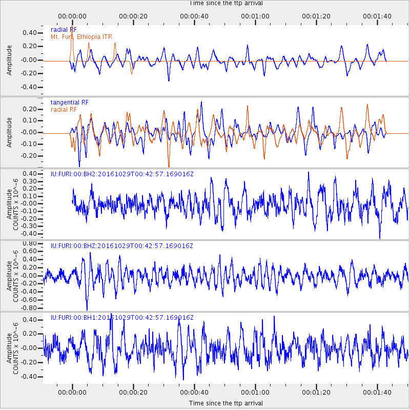
FURI Mt. Furi, Ethiopia - Earthquake Result Viewer
*The percent match for this event was below the threshold and hence no stack was calculated.
| Earthquake location: |
Prince Edward Islands Region |
| Earthquake latitude/longitude: |
-47.3/32.4 |
| Earthquake time(UTC): |
2016/10/29 (303) 00:33:47 GMT |
| Earthquake Depth: |
10 km |
| Earthquake Magnitude: |
5.5 MB |
| Earthquake Catalog/Contributor: |
NEIC PDE/NEIC COMCAT |
|
| Network: |
IU Global Seismograph Network (GSN - IRIS/USGS) |
| Station: |
FURI Mt. Furi, Ethiopia |
| Lat/Lon: |
8.90 N/38.68 E |
| Elevation: |
2570 m |
|
| Distance: |
56.3 deg |
| Az: |
7.439 deg |
| Baz: |
185.113 deg |
| Ray Param: |
$rayparam |
*The percent match for this event was below the threshold and hence was not used in the summary stack. |
|
| Radial Match: |
64.40215 % |
| Radial Bump: |
400 |
| Transverse Match: |
58.37736 % |
| Transverse Bump: |
400 |
| SOD ConfigId: |
1815711 |
| Insert Time: |
2016-11-12 00:34:37.802 +0000 |
| GWidth: |
2.5 |
| Max Bumps: |
400 |
| Tol: |
0.001 |
|
Signal To Noise
| Channel | StoN | STA | LTA |
| IU:FURI:00:BHZ:20161029T00:42:57.169016Z | 3.0194006 | 2.8222476E-7 | 9.3470454E-8 |
| IU:FURI:00:BH1:20161029T00:42:57.169016Z | 1.4206941 | 1.2191528E-7 | 8.581388E-8 |
| IU:FURI:00:BH2:20161029T00:42:57.169016Z | 1.2345512 | 1.03725085E-7 | 8.401846E-8 |
| Arrivals |
| Ps | |
| PpPs | |
| PsPs/PpSs | |


