You are here: Home > Network List > TA - USArray Transportable Network (new EarthScope stations) Stations List
> Station A21K Barrow, AK, USA > Earthquake Result Viewer
A21K Barrow, AK, USA - Earthquake Result Viewer
| Earthquake location: |
Panama-Costa Rica Border Region |
| Earthquake latitude/longitude: |
8.6/-82.8 |
| Earthquake time(UTC): |
2019/05/12 (132) 19:24:50 GMT |
| Earthquake Depth: |
19 km |
| Earthquake Magnitude: |
6.1 Mww |
| Earthquake Catalog/Contributor: |
NEIC PDE/us |
|
| Network: |
TA USArray Transportable Network (new EarthScope stations) |
| Station: |
A21K Barrow, AK, USA |
| Lat/Lon: |
71.32 N/156.62 W |
| Elevation: |
577 m |
|
| Distance: |
76.7 deg |
| Az: |
341.466 deg |
| Baz: |
102.678 deg |
| Ray Param: |
0.050790846 |
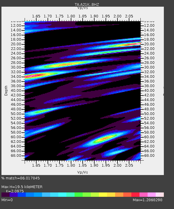
| Estimated Moho Depth: |
19.5 km |
| Estimated Crust Vp/Vs: |
2.10 |
| Assumed Crust Vp: |
6.048 km/s |
| Estimated Crust Vs: |
2.883 km/s |
| Estimated Crust Poisson's Ratio: |
0.35 |
|
| Radial Match: |
86.017845 % |
| Radial Bump: |
400 |
| Transverse Match: |
84.618286 % |
| Transverse Bump: |
400 |
| SOD ConfigId: |
18369291 |
| Insert Time: |
2019-05-26 19:31:39.861 +0000 |
| GWidth: |
2.5 |
| Max Bumps: |
400 |
| Tol: |
0.001 |
|
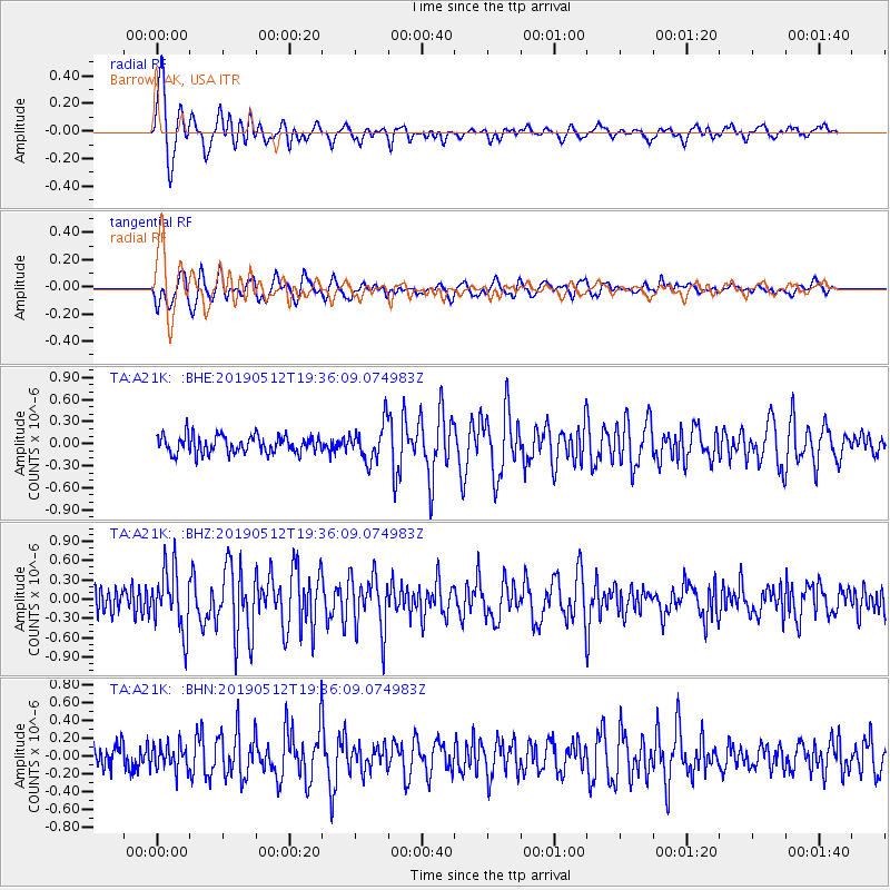
Signal To Noise
| Channel | StoN | STA | LTA |
| TA:A21K: :BHZ:20190512T19:36:09.074983Z | 2.891405 | 4.7478193E-7 | 1.6420456E-7 |
| TA:A21K: :BHN:20190512T19:36:09.074983Z | 1.3841759 | 1.400198E-7 | 1.0115752E-7 |
| TA:A21K: :BHE:20190512T19:36:09.074983Z | 2.0680354 | 2.472654E-7 | 1.1956537E-7 |
| Arrivals |
| Ps | 3.6 SECOND |
| PpPs | 9.8 SECOND |
| PsPs/PpSs | 13 SECOND |


