You are here: Home > Network List > TA - USArray Transportable Network (new EarthScope stations) Stations List
> Station B18K Kokolik River, AK, USA > Earthquake Result Viewer
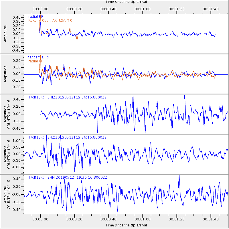
B18K Kokolik River, AK, USA - Earthquake Result Viewer
*The percent match for this event was below the threshold and hence no stack was calculated.
| Earthquake location: |
Panama-Costa Rica Border Region |
| Earthquake latitude/longitude: |
8.6/-82.8 |
| Earthquake time(UTC): |
2019/05/12 (132) 19:24:50 GMT |
| Earthquake Depth: |
19 km |
| Earthquake Magnitude: |
6.1 Mww |
| Earthquake Catalog/Contributor: |
NEIC PDE/us |
|
| Network: |
TA USArray Transportable Network (new EarthScope stations) |
| Station: |
B18K Kokolik River, AK, USA |
| Lat/Lon: |
69.36 N/161.80 W |
| Elevation: |
222 m |
|
| Distance: |
78.1 deg |
| Az: |
339.171 deg |
| Baz: |
97.298 deg |
| Ray Param: |
$rayparam |
*The percent match for this event was below the threshold and hence was not used in the summary stack. |
|
| Radial Match: |
74.37577 % |
| Radial Bump: |
400 |
| Transverse Match: |
75.3668 % |
| Transverse Bump: |
400 |
| SOD ConfigId: |
18369291 |
| Insert Time: |
2019-05-26 19:31:39.920 +0000 |
| GWidth: |
2.5 |
| Max Bumps: |
400 |
| Tol: |
0.001 |
|
Signal To Noise
| Channel | StoN | STA | LTA |
| TA:B18K: :BHZ:20190512T19:36:16.80002Z | 4.035052 | 4.842495E-7 | 1.2001072E-7 |
| TA:B18K: :BHN:20190512T19:36:16.80002Z | 1.532184 | 8.752534E-8 | 5.7124566E-8 |
| TA:B18K: :BHE:20190512T19:36:16.80002Z | 2.783048 | 1.3815828E-7 | 4.9642797E-8 |
| Arrivals |
| Ps | |
| PpPs | |
| PsPs/PpSs | |


