You are here: Home > Network List > TS - TERRAscope (Southern California Seismic Network) Stations List
> Station GLA Glamis, California, USA > Earthquake Result Viewer
GLA Glamis, California, USA - Earthquake Result Viewer

| Earthquake location: |
Near Coast Of Northern Chile |
| Earthquake latitude/longitude: |
-23.3/-70.6 |
| Earthquake time(UTC): |
1995/07/30 (211) 21:05:50 GMT |
| Earthquake Depth: |
33 km |
| Earthquake Magnitude: |
5.6 MB, 5.6 MS, 5.4 UNKNOWN, 6.1 MW |
| Earthquake Catalog/Contributor: |
WHDF/NEIC |
|
| Network: |
TS TERRAscope (Southern California Seismic Network) |
| Station: |
GLA Glamis, California, USA |
| Lat/Lon: |
33.05 N/114.83 W |
| Elevation: |
627 m |
|
| Distance: |
70.2 deg |
| Az: |
321.472 deg |
| Baz: |
137.014 deg |
| Ray Param: |
0.055121556 |
| Estimated Moho Depth: |
61.25 km |
| Estimated Crust Vp/Vs: |
1.70 |
| Assumed Crust Vp: |
6.155 km/s |
| Estimated Crust Vs: |
3.62 km/s |
| Estimated Crust Poisson's Ratio: |
0.24 |
|
| Radial Match: |
86.52676 % |
| Radial Bump: |
400 |
| Transverse Match: |
77.70775 % |
| Transverse Bump: |
400 |
| SOD ConfigId: |
6273 |
| Insert Time: |
2010-02-26 14:12:37.782 +0000 |
| GWidth: |
2.5 |
| Max Bumps: |
400 |
| Tol: |
0.001 |
|
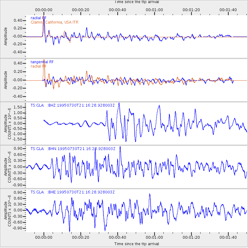
Signal To Noise
| Channel | StoN | STA | LTA |
| TS:GLA: :BHN:19950730T21:16:28.928003Z | 1.5423033 | 1.8727862E-7 | 1.2142787E-7 |
| TS:GLA: :BHE:19950730T21:16:28.928003Z | 1.0320596 | 1.242102E-7 | 1.2035177E-7 |
| TS:GLA: :BHZ:19950730T21:16:28.928003Z | 2.8461995 | 3.5279325E-7 | 1.239524E-7 |
| Arrivals |
| Ps | 7.2 SECOND |
| PpPs | 26 SECOND |
| PsPs/PpSs | 33 SECOND |


