You are here: Home > Network List > TA - USArray Transportable Network (new EarthScope stations) Stations List
> Station G17A Pierce Place, Pray, MT, USA > Earthquake Result Viewer
G17A Pierce Place, Pray, MT, USA - Earthquake Result Viewer
| Earthquake location: |
Tonga Islands |
| Earthquake latitude/longitude: |
-21.9/-173.8 |
| Earthquake time(UTC): |
2008/10/19 (293) 05:10:33 GMT |
| Earthquake Depth: |
29 km |
| Earthquake Magnitude: |
6.8 MB, 7.0 MS, 6.9 MW, 6.9 MW |
| Earthquake Catalog/Contributor: |
WHDF/NEIC |
|
| Network: |
TA USArray Transportable Network (new EarthScope stations) |
| Station: |
G17A Pierce Place, Pray, MT, USA |
| Lat/Lon: |
45.32 N/110.74 W |
| Elevation: |
1574 m |
|
| Distance: |
88.0 deg |
| Az: |
39.008 deg |
| Baz: |
235.972 deg |
| Ray Param: |
0.04285364 |
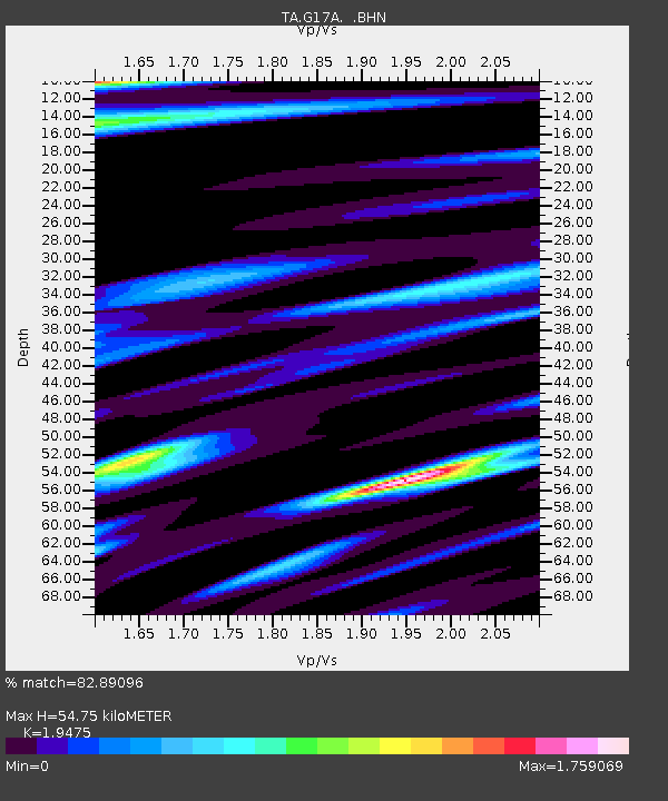
| Estimated Moho Depth: |
54.75 km |
| Estimated Crust Vp/Vs: |
1.95 |
| Assumed Crust Vp: |
6.35 km/s |
| Estimated Crust Vs: |
3.261 km/s |
| Estimated Crust Poisson's Ratio: |
0.32 |
|
| Radial Match: |
82.89096 % |
| Radial Bump: |
319 |
| Transverse Match: |
89.97999 % |
| Transverse Bump: |
347 |
| SOD ConfigId: |
2556 |
| Insert Time: |
2010-03-06 22:24:09.947 +0000 |
| GWidth: |
2.5 |
| Max Bumps: |
400 |
| Tol: |
0.001 |
|
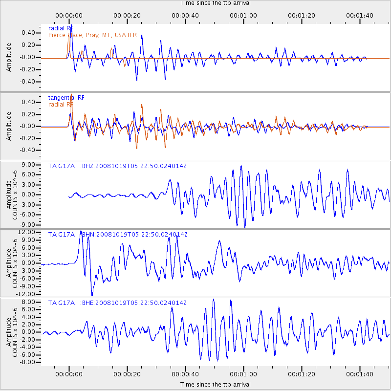
Signal To Noise
| Channel | StoN | STA | LTA |
| TA:G17A: :BHN:20081019T05:22:50.024014Z | 42.3956 | 5.4802863E-6 | 1.2926546E-7 |
| TA:G17A: :BHE:20081019T05:22:50.024014Z | 1.4851543 | 4.5358053E-7 | 3.0540969E-7 |
| TA:G17A: :BHZ:20081019T05:22:50.024014Z | 5.2911882 | 1.7585257E-6 | 3.3234988E-7 |
| Arrivals |
| Ps | 8.3 SECOND |
| PpPs | 25 SECOND |
| PsPs/PpSs | 33 SECOND |


