You are here: Home > Network List > TA - USArray Transportable Network (new EarthScope stations) Stations List
> Station I30M Mount Dempster, Yukon, CAN > Earthquake Result Viewer
I30M Mount Dempster, Yukon, CAN - Earthquake Result Viewer
| Earthquake location: |
Panama-Costa Rica Border Region |
| Earthquake latitude/longitude: |
8.6/-82.8 |
| Earthquake time(UTC): |
2019/05/12 (132) 19:24:50 GMT |
| Earthquake Depth: |
19 km |
| Earthquake Magnitude: |
6.1 Mww |
| Earthquake Catalog/Contributor: |
NEIC PDE/us |
|
| Network: |
TA USArray Transportable Network (new EarthScope stations) |
| Station: |
I30M Mount Dempster, Yukon, CAN |
| Lat/Lon: |
65.22 N/136.38 W |
| Elevation: |
1399 m |
|
| Distance: |
67.5 deg |
| Az: |
338.48 deg |
| Baz: |
120.596 deg |
| Ray Param: |
0.056890994 |
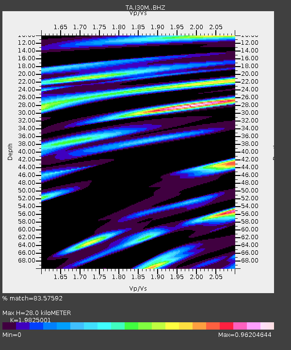
| Estimated Moho Depth: |
28.0 km |
| Estimated Crust Vp/Vs: |
1.98 |
| Assumed Crust Vp: |
6.566 km/s |
| Estimated Crust Vs: |
3.312 km/s |
| Estimated Crust Poisson's Ratio: |
0.33 |
|
| Radial Match: |
83.57592 % |
| Radial Bump: |
400 |
| Transverse Match: |
78.041405 % |
| Transverse Bump: |
400 |
| SOD ConfigId: |
18369291 |
| Insert Time: |
2019-05-26 19:32:25.070 +0000 |
| GWidth: |
2.5 |
| Max Bumps: |
400 |
| Tol: |
0.001 |
|
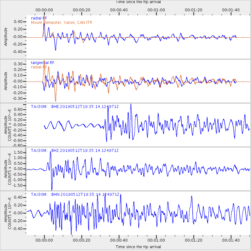
Signal To Noise
| Channel | StoN | STA | LTA |
| TA:I30M: :BHZ:20190512T19:35:14.124971Z | 6.68888 | 7.384391E-7 | 1.1039802E-7 |
| TA:I30M: :BHN:20190512T19:35:14.124971Z | 1.2365572 | 9.584193E-8 | 7.7507075E-8 |
| TA:I30M: :BHE:20190512T19:35:14.124971Z | 2.9501805 | 2.6507016E-7 | 8.98488E-8 |
| Arrivals |
| Ps | 4.3 SECOND |
| PpPs | 12 SECOND |
| PsPs/PpSs | 17 SECOND |


