You are here: Home > Network List > TS - TERRAscope (Southern California Seismic Network) Stations List
> Station GLA Glamis, California, USA > Earthquake Result Viewer
GLA Glamis, California, USA - Earthquake Result Viewer
| Earthquake location: |
New Britain Region, P.N.G. |
| Earthquake latitude/longitude: |
-4.8/151.5 |
| Earthquake time(UTC): |
1995/08/14 (226) 04:37:17 GMT |
| Earthquake Depth: |
126 km |
| Earthquake Magnitude: |
6.3 MB, 6.3 MS, 6.4 UNKNOWN |
| Earthquake Catalog/Contributor: |
WHDF/NEIC |
|
| Network: |
TS TERRAscope (Southern California Seismic Network) |
| Station: |
GLA Glamis, California, USA |
| Lat/Lon: |
33.05 N/114.83 W |
| Elevation: |
627 m |
|
| Distance: |
95.7 deg |
| Az: |
57.379 deg |
| Baz: |
267.949 deg |
| Ray Param: |
0.04062645 |
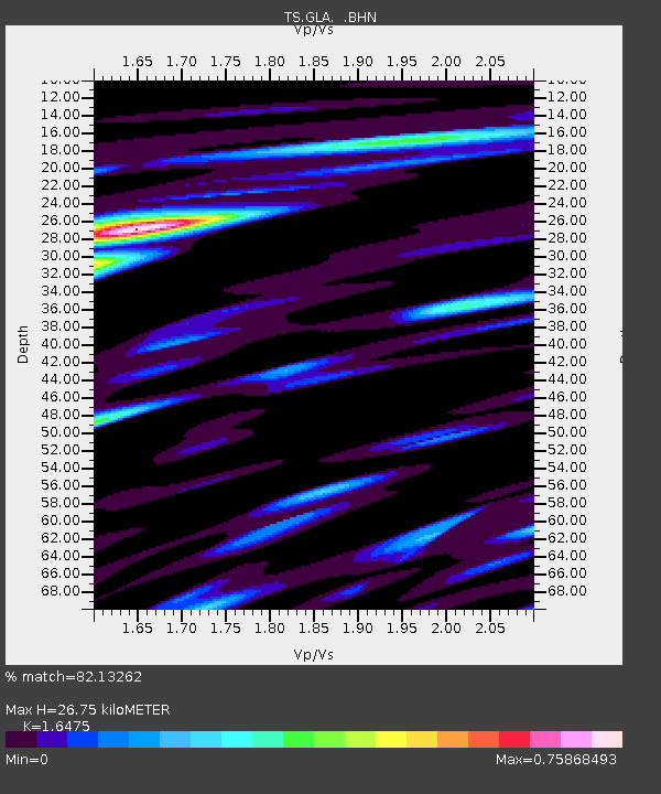
| Estimated Moho Depth: |
26.75 km |
| Estimated Crust Vp/Vs: |
1.65 |
| Assumed Crust Vp: |
6.155 km/s |
| Estimated Crust Vs: |
3.736 km/s |
| Estimated Crust Poisson's Ratio: |
0.21 |
|
| Radial Match: |
82.13262 % |
| Radial Bump: |
400 |
| Transverse Match: |
73.66476 % |
| Transverse Bump: |
400 |
| SOD ConfigId: |
6273 |
| Insert Time: |
2010-02-26 14:12:39.403 +0000 |
| GWidth: |
2.5 |
| Max Bumps: |
400 |
| Tol: |
0.001 |
|
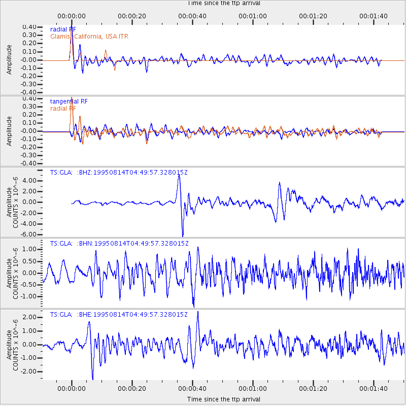
Signal To Noise
| Channel | StoN | STA | LTA |
| TS:GLA: :BHN:19950814T04:49:57.328015Z | 1.3457654 | 2.2738186E-7 | 1.68961E-7 |
| TS:GLA: :BHE:19950814T04:49:57.328015Z | 1.5320779 | 2.540011E-7 | 1.6578862E-7 |
| TS:GLA: :BHZ:19950814T04:49:57.328015Z | 2.1419947 | 4.0091948E-7 | 1.871711E-7 |
| Arrivals |
| Ps | 2.9 SECOND |
| PpPs | 11 SECOND |
| PsPs/PpSs | 14 SECOND |


