You are here: Home > Network List > TA - USArray Transportable Network (new EarthScope stations) Stations List
> Station G17A Pierce Place, Pray, MT, USA > Earthquake Result Viewer
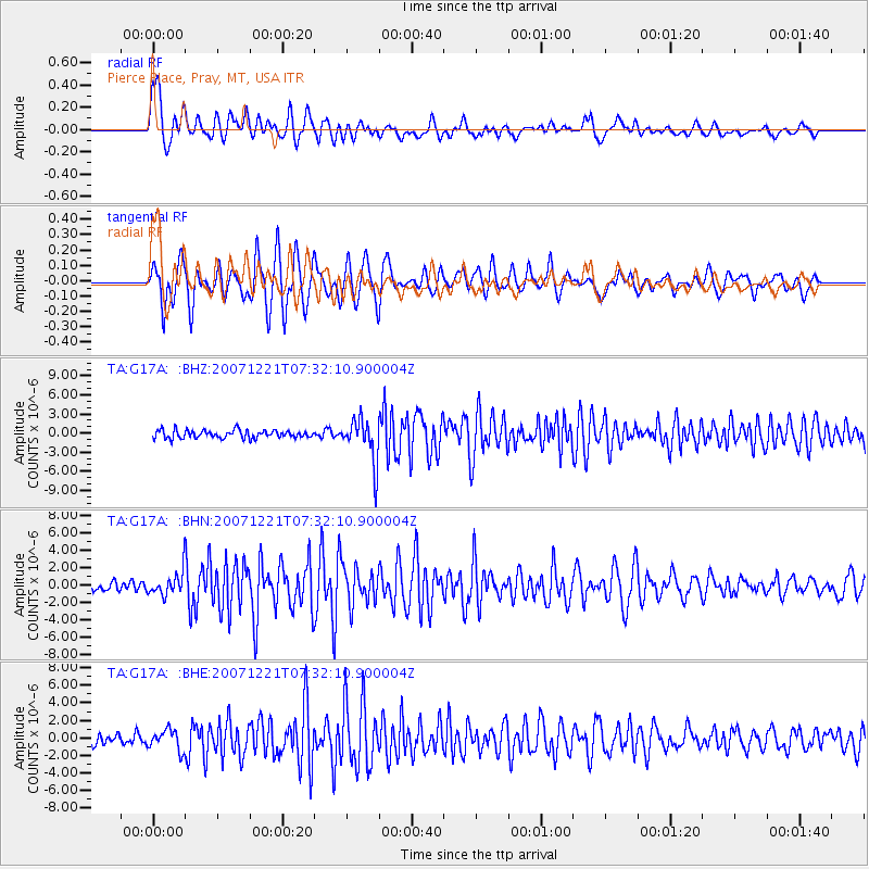
G17A Pierce Place, Pray, MT, USA - Earthquake Result Viewer
| Earthquake location: |
Andreanof Islands, Aleutian Is. |
| Earthquake latitude/longitude: |
51.4/-179.0 |
| Earthquake time(UTC): |
2007/12/21 (355) 07:24:34 GMT |
| Earthquake Depth: |
30 km |
| Earthquake Magnitude: |
6.1 MB, 6.2 MW, 6.3 ML |
| Earthquake Catalog/Contributor: |
WHDF/NEIC |
|
| Network: |
TA USArray Transportable Network (new EarthScope stations) |
| Station: |
G17A Pierce Place, Pray, MT, USA |
| Lat/Lon: |
45.32 N/110.74 W |
| Elevation: |
1574 m |
|
| Distance: |
44.3 deg |
| Az: |
69.84 deg |
| Baz: |
303.462 deg |
| Ray Param: |
0.07196724 |
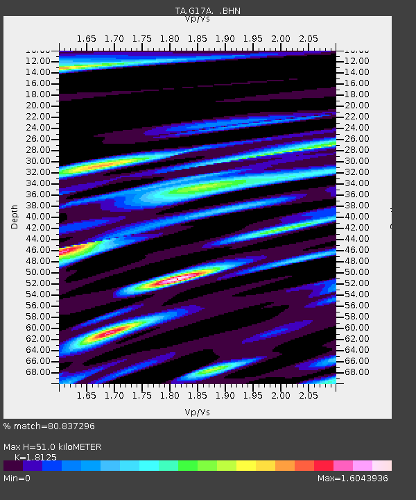
| Estimated Moho Depth: |
51.0 km |
| Estimated Crust Vp/Vs: |
1.81 |
| Assumed Crust Vp: |
6.35 km/s |
| Estimated Crust Vs: |
3.503 km/s |
| Estimated Crust Poisson's Ratio: |
0.28 |
|
| Radial Match: |
80.837296 % |
| Radial Bump: |
400 |
| Transverse Match: |
85.534454 % |
| Transverse Bump: |
400 |
| SOD ConfigId: |
2564 |
| Insert Time: |
2010-03-06 22:24:41.175 +0000 |
| GWidth: |
2.5 |
| Max Bumps: |
400 |
| Tol: |
0.001 |
|
Signal To Noise
| Channel | StoN | STA | LTA |
| TA:G17A: :BHN:20071221T07:32:10.900004Z | 2.1943429 | 1.332496E-6 | 6.072415E-7 |
| TA:G17A: :BHE:20071221T07:32:10.900004Z | 1.6640471 | 1.1455344E-6 | 6.884026E-7 |
| TA:G17A: :BHZ:20071221T07:32:10.900004Z | 5.4349957 | 3.4317816E-6 | 6.3142306E-7 |
| Arrivals |
| Ps | 6.9 SECOND |
| PpPs | 21 SECOND |
| PsPs/PpSs | 28 SECOND |


