You are here: Home > Network List > TS - TERRAscope (Southern California Seismic Network) Stations List
> Station GLA Glamis, California, USA > Earthquake Result Viewer
GLA Glamis, California, USA - Earthquake Result Viewer

| Earthquake location: |
Solomon Islands |
| Earthquake latitude/longitude: |
-5.8/154.3 |
| Earthquake time(UTC): |
1995/08/16 (228) 23:10:28 GMT |
| Earthquake Depth: |
74 km |
| Earthquake Magnitude: |
6.1 MB, 7.2 MS, 7.2 UNKNOWN, 7.2 MW |
| Earthquake Catalog/Contributor: |
WHDF/NEIC |
|
| Network: |
TS TERRAscope (Southern California Seismic Network) |
| Station: |
GLA Glamis, California, USA |
| Lat/Lon: |
33.05 N/114.83 W |
| Elevation: |
627 m |
|
| Distance: |
93.9 deg |
| Az: |
57.317 deg |
| Baz: |
265.666 deg |
| Ray Param: |
0.041130275 |
| Estimated Moho Depth: |
26.5 km |
| Estimated Crust Vp/Vs: |
1.65 |
| Assumed Crust Vp: |
6.155 km/s |
| Estimated Crust Vs: |
3.73 km/s |
| Estimated Crust Poisson's Ratio: |
0.21 |
|
| Radial Match: |
94.528275 % |
| Radial Bump: |
400 |
| Transverse Match: |
80.8282 % |
| Transverse Bump: |
400 |
| SOD ConfigId: |
6273 |
| Insert Time: |
2010-02-26 14:12:40.783 +0000 |
| GWidth: |
2.5 |
| Max Bumps: |
400 |
| Tol: |
0.001 |
|
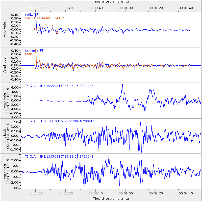
Signal To Noise
| Channel | StoN | STA | LTA |
| TS:GLA: :BHN:19950816T23:23:06.879004Z | 1.2258303 | 8.598108E-8 | 7.01411E-8 |
| TS:GLA: :BHE:19950816T23:23:06.879004Z | 0.94921833 | 9.8564804E-8 | 1.0383786E-7 |
| TS:GLA: :BHZ:19950816T23:23:06.879004Z | 2.4657962 | 2.6981442E-7 | 1.0942284E-7 |
| Arrivals |
| Ps | 2.9 SECOND |
| PpPs | 11 SECOND |
| PsPs/PpSs | 14 SECOND |


