You are here: Home > Network List > TA - USArray Transportable Network (new EarthScope stations) Stations List
> Station G17A Pierce Place, Pray, MT, USA > Earthquake Result Viewer
G17A Pierce Place, Pray, MT, USA - Earthquake Result Viewer
| Earthquake location: |
Peru-Ecuador Border Region |
| Earthquake latitude/longitude: |
-2.3/-77.8 |
| Earthquake time(UTC): |
2007/11/16 (320) 03:13:00 GMT |
| Earthquake Depth: |
123 km |
| Earthquake Magnitude: |
6.3 MB, 6.8 MW, 6.7 MW |
| Earthquake Catalog/Contributor: |
WHDF/NEIC |
|
| Network: |
TA USArray Transportable Network (new EarthScope stations) |
| Station: |
G17A Pierce Place, Pray, MT, USA |
| Lat/Lon: |
45.32 N/110.74 W |
| Elevation: |
1574 m |
|
| Distance: |
55.7 deg |
| Az: |
332.361 deg |
| Baz: |
138.929 deg |
| Ray Param: |
0.06423595 |
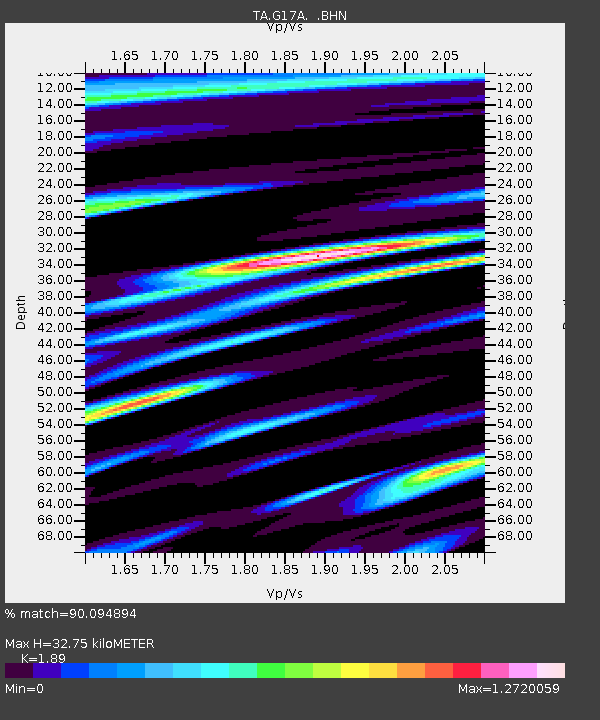
| Estimated Moho Depth: |
32.75 km |
| Estimated Crust Vp/Vs: |
1.89 |
| Assumed Crust Vp: |
6.35 km/s |
| Estimated Crust Vs: |
3.36 km/s |
| Estimated Crust Poisson's Ratio: |
0.31 |
|
| Radial Match: |
90.094894 % |
| Radial Bump: |
400 |
| Transverse Match: |
86.67743 % |
| Transverse Bump: |
400 |
| SOD ConfigId: |
2564 |
| Insert Time: |
2010-03-06 22:24:46.336 +0000 |
| GWidth: |
2.5 |
| Max Bumps: |
400 |
| Tol: |
0.001 |
|
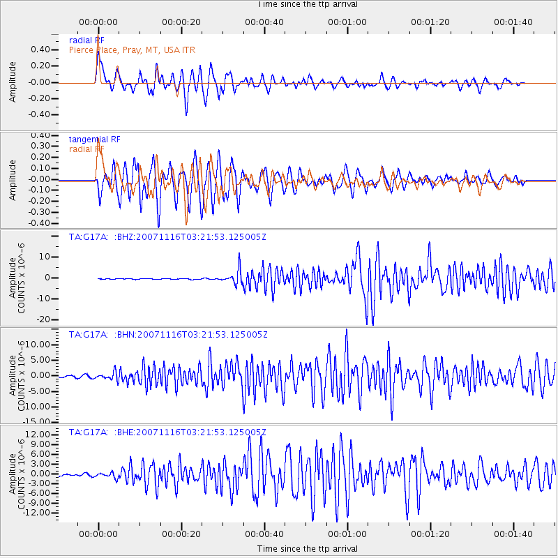
Signal To Noise
| Channel | StoN | STA | LTA |
| TA:G17A: :BHN:20071116T03:21:53.125005Z | 3.661156 | 1.2597309E-6 | 3.4408012E-7 |
| TA:G17A: :BHE:20071116T03:21:53.125005Z | 1.9195079 | 7.9506384E-7 | 4.1420193E-7 |
| TA:G17A: :BHZ:20071116T03:21:53.125005Z | 22.127878 | 3.5685453E-6 | 1.612692E-7 |
| Arrivals |
| Ps | 4.8 SECOND |
| PpPs | 14 SECOND |
| PsPs/PpSs | 19 SECOND |


