You are here: Home > Network List > TA - USArray Transportable Network (new EarthScope stations) Stations List
> Station G17A Pierce Place, Pray, MT, USA > Earthquake Result Viewer
G17A Pierce Place, Pray, MT, USA - Earthquake Result Viewer
| Earthquake location: |
Mariana Islands |
| Earthquake latitude/longitude: |
18.9/145.4 |
| Earthquake time(UTC): |
2007/10/31 (304) 03:30:17 GMT |
| Earthquake Depth: |
223 km |
| Earthquake Magnitude: |
6.2 MB, 7.2 MW, 7.2 MW |
| Earthquake Catalog/Contributor: |
WHDF/NEIC |
|
| Network: |
TA USArray Transportable Network (new EarthScope stations) |
| Station: |
G17A Pierce Place, Pray, MT, USA |
| Lat/Lon: |
45.32 N/110.74 W |
| Elevation: |
1574 m |
|
| Distance: |
86.1 deg |
| Az: |
43.349 deg |
| Baz: |
292.902 deg |
| Ray Param: |
0.043747477 |
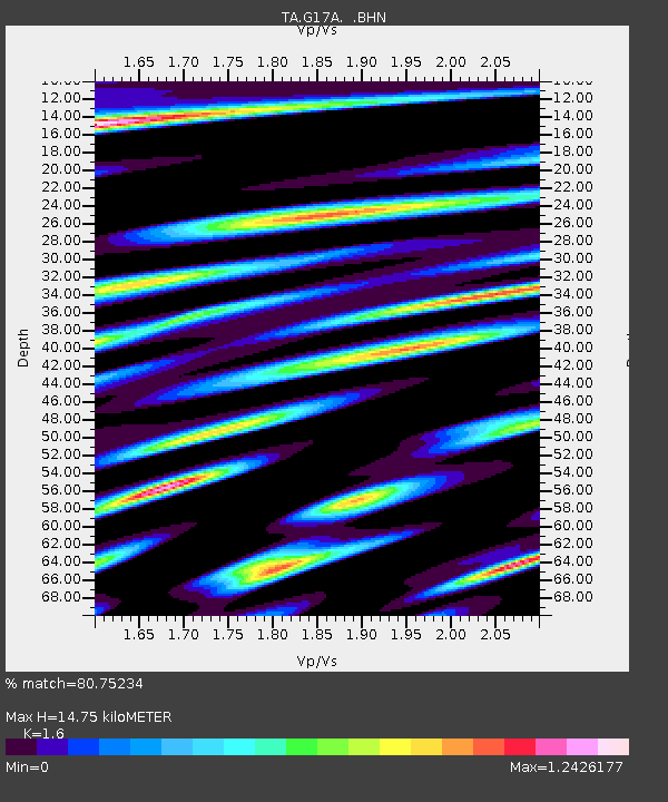
| Estimated Moho Depth: |
14.75 km |
| Estimated Crust Vp/Vs: |
1.60 |
| Assumed Crust Vp: |
6.35 km/s |
| Estimated Crust Vs: |
3.969 km/s |
| Estimated Crust Poisson's Ratio: |
0.18 |
|
| Radial Match: |
80.75234 % |
| Radial Bump: |
400 |
| Transverse Match: |
82.364265 % |
| Transverse Bump: |
400 |
| SOD ConfigId: |
2564 |
| Insert Time: |
2010-03-06 22:24:53.373 +0000 |
| GWidth: |
2.5 |
| Max Bumps: |
400 |
| Tol: |
0.001 |
|
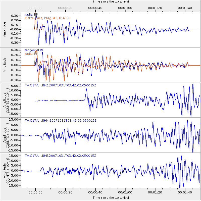
Signal To Noise
| Channel | StoN | STA | LTA |
| TA:G17A: :BHN:20071031T03:42:02.050015Z | 2.8547544 | 1.1435822E-6 | 4.0058865E-7 |
| TA:G17A: :BHE:20071031T03:42:02.050015Z | 3.4839494 | 1.2581978E-6 | 3.6114122E-7 |
| TA:G17A: :BHZ:20071031T03:42:02.050015Z | 16.252733 | 4.5363067E-6 | 2.791104E-7 |
| Arrivals |
| Ps | 1.4 SECOND |
| PpPs | 5.9 SECOND |
| PsPs/PpSs | 7.3 SECOND |


