You are here: Home > Network List > TA - USArray Transportable Network (new EarthScope stations) Stations List
> Station G17A Pierce Place, Pray, MT, USA > Earthquake Result Viewer
G17A Pierce Place, Pray, MT, USA - Earthquake Result Viewer
| Earthquake location: |
North Of Svalbard |
| Earthquake latitude/longitude: |
80.3/-1.9 |
| Earthquake time(UTC): |
2009/03/06 (065) 10:50:29 GMT |
| Earthquake Depth: |
9.0 km |
| Earthquake Magnitude: |
6.6 MB, 6.5 MS, 6.5 MW, 6.4 MW |
| Earthquake Catalog/Contributor: |
WHDF/NEIC |
|
| Network: |
TA USArray Transportable Network (new EarthScope stations) |
| Station: |
G17A Pierce Place, Pray, MT, USA |
| Lat/Lon: |
45.32 N/110.74 W |
| Elevation: |
1574 m |
|
| Distance: |
48.7 deg |
| Az: |
297.33 deg |
| Baz: |
12.3 deg |
| Ray Param: |
0.06918161 |
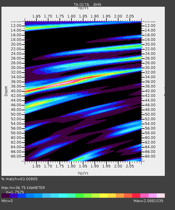
| Estimated Moho Depth: |
36.75 km |
| Estimated Crust Vp/Vs: |
1.75 |
| Assumed Crust Vp: |
6.35 km/s |
| Estimated Crust Vs: |
3.623 km/s |
| Estimated Crust Poisson's Ratio: |
0.26 |
|
| Radial Match: |
83.00985 % |
| Radial Bump: |
400 |
| Transverse Match: |
79.10527 % |
| Transverse Bump: |
396 |
| SOD ConfigId: |
2658 |
| Insert Time: |
2010-03-06 22:25:01.990 +0000 |
| GWidth: |
2.5 |
| Max Bumps: |
400 |
| Tol: |
0.001 |
|
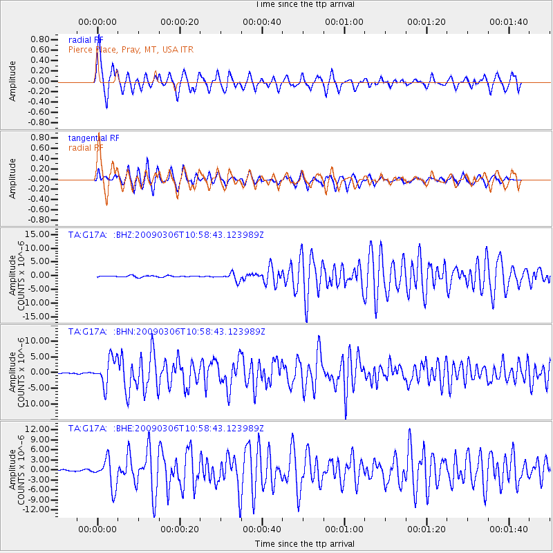
Signal To Noise
| Channel | StoN | STA | LTA |
| TA:G17A: :BHN:20090306T10:58:43.123989Z | 39.11133 | 4.4765197E-6 | 1.1445584E-7 |
| TA:G17A: :BHE:20090306T10:58:43.123989Z | 14.443804 | 4.3861387E-6 | 3.036692E-7 |
| TA:G17A: :BHZ:20090306T10:58:43.123989Z | 5.7140474 | 1.4529443E-6 | 2.5427585E-7 |
| Arrivals |
| Ps | 4.6 SECOND |
| PpPs | 15 SECOND |
| PsPs/PpSs | 20 SECOND |


