You are here: Home > Network List > TA - USArray Transportable Network (new EarthScope stations) Stations List
> Station G17A Pierce Place, Pray, MT, USA > Earthquake Result Viewer
G17A Pierce Place, Pray, MT, USA - Earthquake Result Viewer
| Earthquake location: |
South Of Panama |
| Earthquake latitude/longitude: |
5.7/-82.8 |
| Earthquake time(UTC): |
2009/03/12 (071) 23:23:34 GMT |
| Earthquake Depth: |
9.0 km |
| Earthquake Magnitude: |
6.1 MB, 5.9 MS, 6.3 MW, 6.2 MW |
| Earthquake Catalog/Contributor: |
WHDF/NEIC |
|
| Network: |
TA USArray Transportable Network (new EarthScope stations) |
| Station: |
G17A Pierce Place, Pray, MT, USA |
| Lat/Lon: |
45.32 N/110.74 W |
| Elevation: |
1574 m |
|
| Distance: |
46.4 deg |
| Az: |
332.801 deg |
| Baz: |
139.855 deg |
| Ray Param: |
0.07067987 |
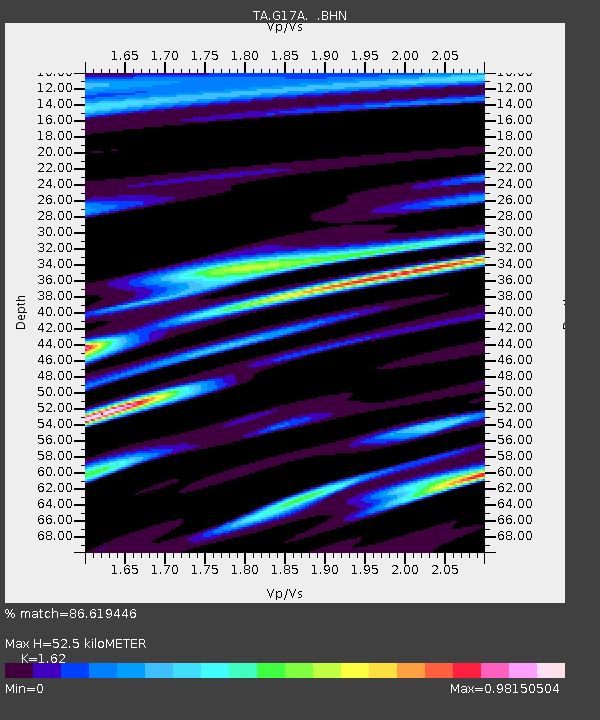
| Estimated Moho Depth: |
52.5 km |
| Estimated Crust Vp/Vs: |
1.62 |
| Assumed Crust Vp: |
6.35 km/s |
| Estimated Crust Vs: |
3.92 km/s |
| Estimated Crust Poisson's Ratio: |
0.19 |
|
| Radial Match: |
86.619446 % |
| Radial Bump: |
400 |
| Transverse Match: |
95.902824 % |
| Transverse Bump: |
332 |
| SOD ConfigId: |
2658 |
| Insert Time: |
2010-03-06 22:25:03.906 +0000 |
| GWidth: |
2.5 |
| Max Bumps: |
400 |
| Tol: |
0.001 |
|
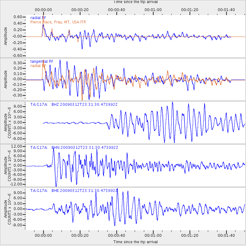
Signal To Noise
| Channel | StoN | STA | LTA |
| TA:G17A: :BHN:20090312T23:31:30.473992Z | 3.9956985 | 5.351415E-7 | 1.339294E-7 |
| TA:G17A: :BHE:20090312T23:31:30.473992Z | 1.32407 | 3.157601E-7 | 2.384769E-7 |
| TA:G17A: :BHZ:20090312T23:31:30.473992Z | 1.1954654 | 2.7185413E-7 | 2.2740443E-7 |
| Arrivals |
| Ps | 5.5 SECOND |
| PpPs | 20 SECOND |
| PsPs/PpSs | 26 SECOND |


