You are here: Home > Network List > TA - USArray Transportable Network (new EarthScope stations) Stations List
> Station G17A Pierce Place, Pray, MT, USA > Earthquake Result Viewer
G17A Pierce Place, Pray, MT, USA - Earthquake Result Viewer
| Earthquake location: |
Taiwan Region |
| Earthquake latitude/longitude: |
24.1/122.2 |
| Earthquake time(UTC): |
2009/07/13 (194) 18:05:01 GMT |
| Earthquake Depth: |
17 km |
| Earthquake Magnitude: |
6.1 MB, 6.3 MS, 6.3 MW, 6.2 MW |
| Earthquake Catalog/Contributor: |
WHDF/NEIC |
|
| Network: |
TA USArray Transportable Network (new EarthScope stations) |
| Station: |
G17A Pierce Place, Pray, MT, USA |
| Lat/Lon: |
45.32 N/110.74 W |
| Elevation: |
1574 m |
|
| Distance: |
95.8 deg |
| Az: |
34.467 deg |
| Baz: |
312.837 deg |
| Ray Param: |
0.040676773 |
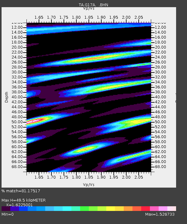
| Estimated Moho Depth: |
49.5 km |
| Estimated Crust Vp/Vs: |
1.62 |
| Assumed Crust Vp: |
6.35 km/s |
| Estimated Crust Vs: |
3.914 km/s |
| Estimated Crust Poisson's Ratio: |
0.19 |
|
| Radial Match: |
81.17517 % |
| Radial Bump: |
400 |
| Transverse Match: |
61.878216 % |
| Transverse Bump: |
395 |
| SOD ConfigId: |
2648 |
| Insert Time: |
2010-03-06 22:25:17.171 +0000 |
| GWidth: |
2.5 |
| Max Bumps: |
400 |
| Tol: |
0.001 |
|
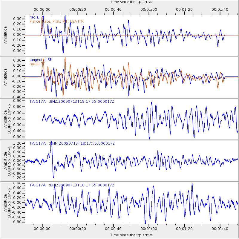
Signal To Noise
| Channel | StoN | STA | LTA |
| TA:G17A: :BHN:20090713T18:17:55.000017Z | 4.4618773 | 3.2652244E-7 | 7.31805E-8 |
| TA:G17A: :BHE:20090713T18:17:55.000017Z | 1.2222255 | 1.3634521E-7 | 1.1155487E-7 |
| TA:G17A: :BHZ:20090713T18:17:55.000017Z | 0.9236234 | 1.4908028E-7 | 1.6140808E-7 |
| Arrivals |
| Ps | 5.0 SECOND |
| PpPs | 20 SECOND |
| PsPs/PpSs | 25 SECOND |


