You are here: Home > Network List > TA - USArray Transportable Network (new EarthScope stations) Stations List
> Station G17A Pierce Place, Pray, MT, USA > Earthquake Result Viewer
G17A Pierce Place, Pray, MT, USA - Earthquake Result Viewer
| Earthquake location: |
Andreanof Islands, Aleutian Is. |
| Earthquake latitude/longitude: |
51.9/-179.4 |
| Earthquake time(UTC): |
2008/04/15 (106) 22:59:51 GMT |
| Earthquake Depth: |
10 km |
| Earthquake Magnitude: |
6.1 MB, 6.4 MS, 6.4 MW, 6.4 MW |
| Earthquake Catalog/Contributor: |
WHDF/NEIC |
|
| Network: |
TA USArray Transportable Network (new EarthScope stations) |
| Station: |
G17A Pierce Place, Pray, MT, USA |
| Lat/Lon: |
45.32 N/110.74 W |
| Elevation: |
1574 m |
|
| Distance: |
44.3 deg |
| Az: |
70.102 deg |
| Baz: |
304.245 deg |
| Ray Param: |
0.071989104 |
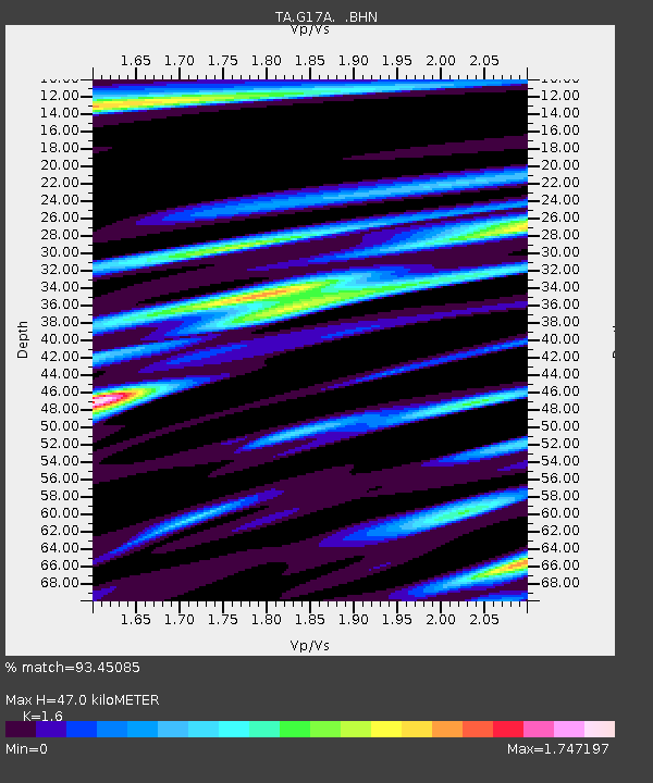
| Estimated Moho Depth: |
47.0 km |
| Estimated Crust Vp/Vs: |
1.60 |
| Assumed Crust Vp: |
6.35 km/s |
| Estimated Crust Vs: |
3.969 km/s |
| Estimated Crust Poisson's Ratio: |
0.18 |
|
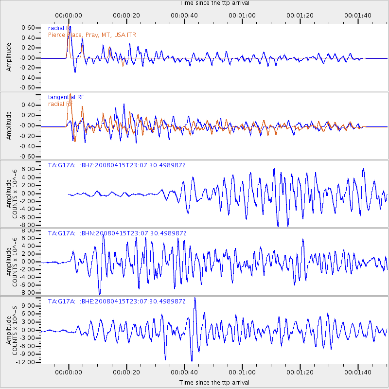
| Radial Match: |
93.45085 % |
| Radial Bump: |
400 |
| Transverse Match: |
94.0385 % |
| Transverse Bump: |
379 |
| SOD ConfigId: |
2504 |
| Insert Time: |
2010-03-06 22:25:32.412 +0000 |
| GWidth: |
2.5 |
| Max Bumps: |
400 |
| Tol: |
0.001 |
|
Signal To Noise
| Channel | StoN | STA | LTA |
| TA:G17A: :BHN:20080415T23:07:30.498987Z | 8.682643 | 1.3390494E-6 | 1.542214E-7 |
| TA:G17A: :BHE:20080415T23:07:30.498987Z | 3.8251371 | 8.107685E-7 | 2.1195801E-7 |
| TA:G17A: :BHZ:20080415T23:07:30.498987Z | 2.2145023 | 6.495024E-7 | 2.9329496E-7 |
| Arrivals |
| Ps | 4.8 SECOND |
| PpPs | 18 SECOND |
| PsPs/PpSs | 23 SECOND |


