You are here: Home > Network List > TA - USArray Transportable Network (new EarthScope stations) Stations List
> Station G17A Pierce Place, Pray, MT, USA > Earthquake Result Viewer
G17A Pierce Place, Pray, MT, USA - Earthquake Result Viewer
| Earthquake location: |
Andreanof Islands, Aleutian Is. |
| Earthquake latitude/longitude: |
51.9/-177.5 |
| Earthquake time(UTC): |
2008/05/02 (123) 01:33:37 GMT |
| Earthquake Depth: |
14 km |
| Earthquake Magnitude: |
6.3 MB, 6.8 MS, 6.6 MW, 6.6 MW |
| Earthquake Catalog/Contributor: |
WHDF/NEIC |
|
| Network: |
TA USArray Transportable Network (new EarthScope stations) |
| Station: |
G17A Pierce Place, Pray, MT, USA |
| Lat/Lon: |
45.32 N/110.74 W |
| Elevation: |
1574 m |
|
| Distance: |
43.2 deg |
| Az: |
71.155 deg |
| Baz: |
303.715 deg |
| Ray Param: |
0.072665006 |
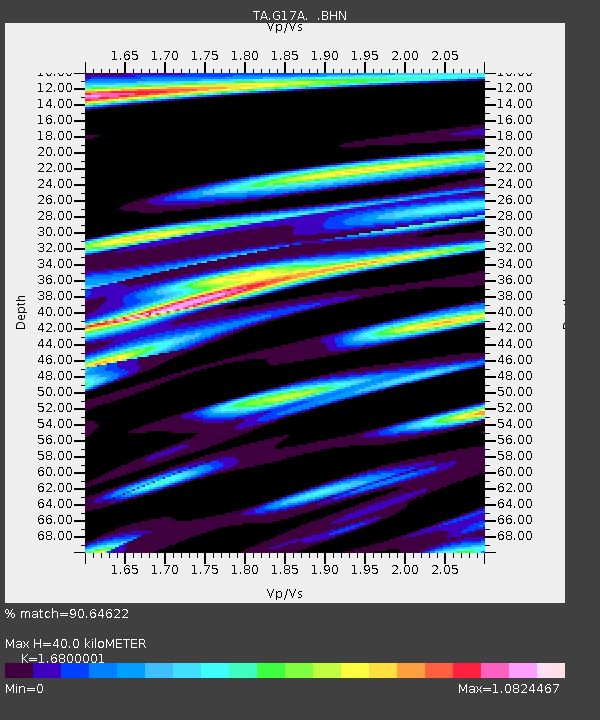
| Estimated Moho Depth: |
40.0 km |
| Estimated Crust Vp/Vs: |
1.68 |
| Assumed Crust Vp: |
6.35 km/s |
| Estimated Crust Vs: |
3.78 km/s |
| Estimated Crust Poisson's Ratio: |
0.23 |
|
| Radial Match: |
90.64622 % |
| Radial Bump: |
372 |
| Transverse Match: |
84.10476 % |
| Transverse Bump: |
367 |
| SOD ConfigId: |
2504 |
| Insert Time: |
2010-03-06 22:25:37.335 +0000 |
| GWidth: |
2.5 |
| Max Bumps: |
400 |
| Tol: |
0.001 |
|

Signal To Noise
| Channel | StoN | STA | LTA |
| TA:G17A: :BHN:20080502T01:41:07.150004Z | 15.142444 | 1.2507556E-6 | 8.259933E-8 |
| TA:G17A: :BHE:20080502T01:41:07.150004Z | 3.3562376 | 4.885095E-7 | 1.4555272E-7 |
| TA:G17A: :BHZ:20080502T01:41:07.150004Z | 2.6560574 | 6.052158E-7 | 2.2786247E-7 |
| Arrivals |
| Ps | 4.6 SECOND |
| PpPs | 16 SECOND |
| PsPs/PpSs | 20 SECOND |


