You are here: Home > Network List > TA - USArray Transportable Network (new EarthScope stations) Stations List
> Station G17A Pierce Place, Pray, MT, USA > Earthquake Result Viewer
G17A Pierce Place, Pray, MT, USA - Earthquake Result Viewer
| Earthquake location: |
Rat Islands, Aleutian Islands |
| Earthquake latitude/longitude: |
51.2/178.8 |
| Earthquake time(UTC): |
2008/05/20 (141) 13:53:35 GMT |
| Earthquake Depth: |
27 km |
| Earthquake Magnitude: |
5.8 MB, 6.0 MS, 6.3 MW, 6.3 MW |
| Earthquake Catalog/Contributor: |
WHDF/NEIC |
|
| Network: |
TA USArray Transportable Network (new EarthScope stations) |
| Station: |
G17A Pierce Place, Pray, MT, USA |
| Lat/Lon: |
45.32 N/110.74 W |
| Elevation: |
1574 m |
|
| Distance: |
45.7 deg |
| Az: |
68.401 deg |
| Baz: |
303.918 deg |
| Ray Param: |
0.07107875 |
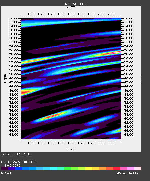
| Estimated Moho Depth: |
26.5 km |
| Estimated Crust Vp/Vs: |
2.10 |
| Assumed Crust Vp: |
6.35 km/s |
| Estimated Crust Vs: |
3.027 km/s |
| Estimated Crust Poisson's Ratio: |
0.35 |
|
| Radial Match: |
85.75187 % |
| Radial Bump: |
400 |
| Transverse Match: |
81.55463 % |
| Transverse Bump: |
400 |
| SOD ConfigId: |
2504 |
| Insert Time: |
2010-03-06 22:25:42.235 +0000 |
| GWidth: |
2.5 |
| Max Bumps: |
400 |
| Tol: |
0.001 |
|

Signal To Noise
| Channel | StoN | STA | LTA |
| TA:G17A: :BHN:20080520T14:01:23.224015Z | 8.072719 | 8.211722E-7 | 1.0172189E-7 |
| TA:G17A: :BHE:20080520T14:01:23.224015Z | 4.387984 | 5.866657E-7 | 1.3369824E-7 |
| TA:G17A: :BHZ:20080520T14:01:23.224015Z | 1.5926974 | 2.7517112E-7 | 1.727705E-7 |
| Arrivals |
| Ps | 4.8 SECOND |
| PpPs | 12 SECOND |
| PsPs/PpSs | 17 SECOND |


