You are here: Home > Network List > TA - USArray Transportable Network (new EarthScope stations) Stations List
> Station G17A Pierce Place, Pray, MT, USA > Earthquake Result Viewer
G17A Pierce Place, Pray, MT, USA - Earthquake Result Viewer
| Earthquake location: |
Central Mid-Atlantic Ridge |
| Earthquake latitude/longitude: |
7.3/-34.9 |
| Earthquake time(UTC): |
2008/05/23 (144) 19:35:34 GMT |
| Earthquake Depth: |
9.0 km |
| Earthquake Magnitude: |
6.0 MB, 6.4 MS, 6.5 MW, 6.5 MW |
| Earthquake Catalog/Contributor: |
WHDF/NEIC |
|
| Network: |
TA USArray Transportable Network (new EarthScope stations) |
| Station: |
G17A Pierce Place, Pray, MT, USA |
| Lat/Lon: |
45.32 N/110.74 W |
| Elevation: |
1574 m |
|
| Distance: |
74.9 deg |
| Az: |
314.878 deg |
| Baz: |
94.916 deg |
| Ray Param: |
0.0520361 |
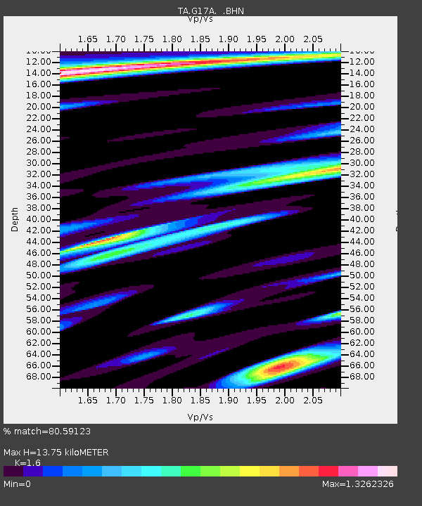
| Estimated Moho Depth: |
13.75 km |
| Estimated Crust Vp/Vs: |
1.60 |
| Assumed Crust Vp: |
6.35 km/s |
| Estimated Crust Vs: |
3.969 km/s |
| Estimated Crust Poisson's Ratio: |
0.18 |
|
| Radial Match: |
80.59123 % |
| Radial Bump: |
400 |
| Transverse Match: |
80.814674 % |
| Transverse Bump: |
335 |
| SOD ConfigId: |
2504 |
| Insert Time: |
2010-03-06 22:25:45.600 +0000 |
| GWidth: |
2.5 |
| Max Bumps: |
400 |
| Tol: |
0.001 |
|
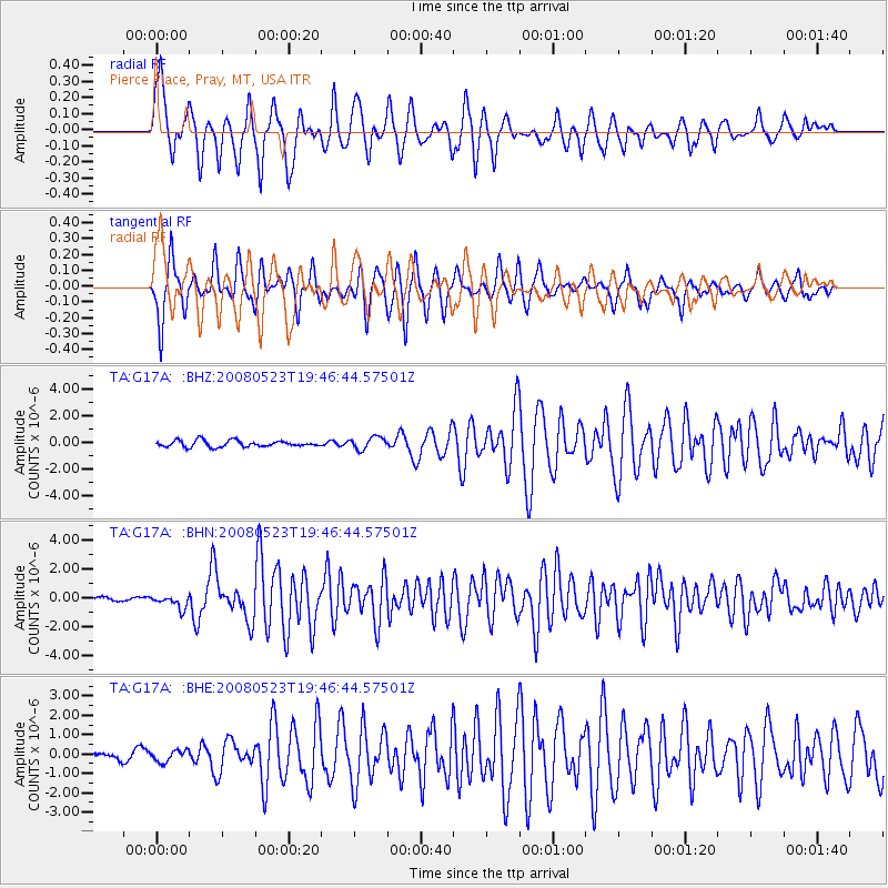
Signal To Noise
| Channel | StoN | STA | LTA |
| TA:G17A: :BHN:20080523T19:46:44.57501Z | 2.414631 | 4.431533E-7 | 1.8352839E-7 |
| TA:G17A: :BHE:20080523T19:46:44.57501Z | 1.2795306 | 2.943233E-7 | 2.3002443E-7 |
| TA:G17A: :BHZ:20080523T19:46:44.57501Z | 1.9808501 | 4.631018E-7 | 2.3378942E-7 |
| Arrivals |
| Ps | 1.3 SECOND |
| PpPs | 5.4 SECOND |
| PsPs/PpSs | 6.8 SECOND |


