You are here: Home > Network List > WY - Yellowstone Wyoming Seismic Network Stations List
> Station YNR Norris Junction, YNP, WY, USA > Earthquake Result Viewer
YNR Norris Junction, YNP, WY, USA - Earthquake Result Viewer

| Earthquake location: |
Panama-Costa Rica Border Region |
| Earthquake latitude/longitude: |
8.6/-82.8 |
| Earthquake time(UTC): |
2019/05/12 (132) 19:24:50 GMT |
| Earthquake Depth: |
19 km |
| Earthquake Magnitude: |
6.1 Mww |
| Earthquake Catalog/Contributor: |
NEIC PDE/us |
|
| Network: |
WY Yellowstone Wyoming Seismic Network |
| Station: |
YNR Norris Junction, YNP, WY, USA |
| Lat/Lon: |
44.72 N/110.68 W |
| Elevation: |
2336 m |
|
| Distance: |
43.3 deg |
| Az: |
330.958 deg |
| Baz: |
137.676 deg |
| Ray Param: |
0.07261352 |
| Estimated Moho Depth: |
16.0 km |
| Estimated Crust Vp/Vs: |
2.09 |
| Assumed Crust Vp: |
6.35 km/s |
| Estimated Crust Vs: |
3.042 km/s |
| Estimated Crust Poisson's Ratio: |
0.35 |
|
| Radial Match: |
80.545296 % |
| Radial Bump: |
400 |
| Transverse Match: |
65.61617 % |
| Transverse Bump: |
400 |
| SOD ConfigId: |
18369291 |
| Insert Time: |
2019-05-26 19:34:41.692 +0000 |
| GWidth: |
2.5 |
| Max Bumps: |
400 |
| Tol: |
0.001 |
|
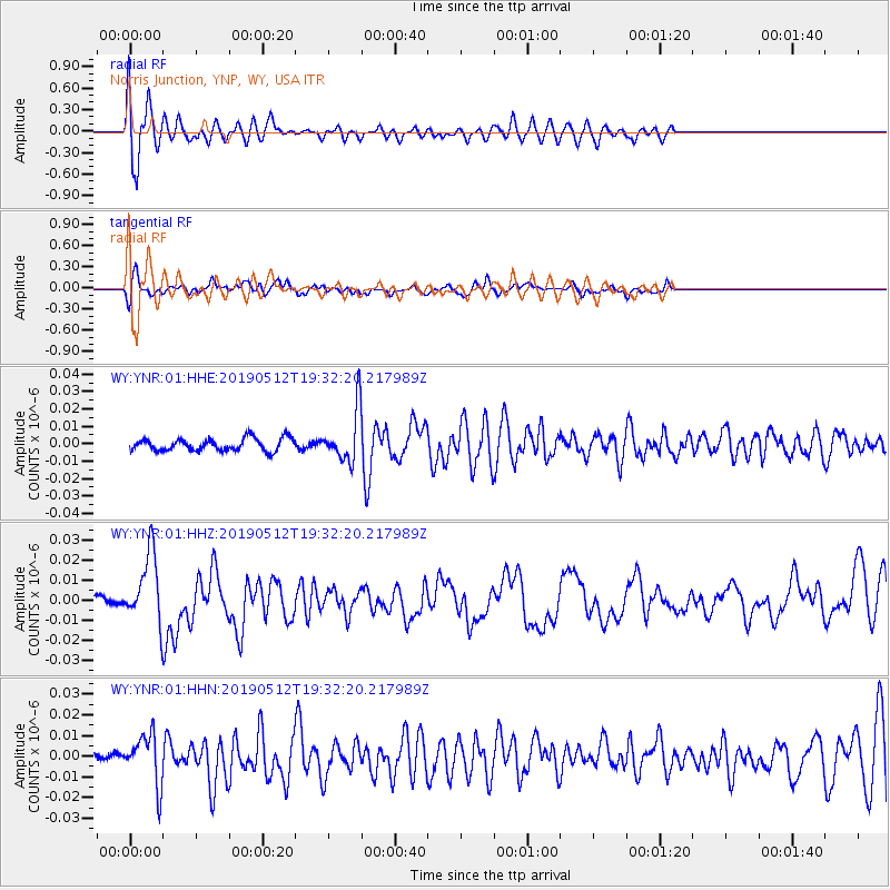
Signal To Noise
| Channel | StoN | STA | LTA |
| WY:YNR:01:HHZ:20190512T19:32:20.217989Z | 6.61995 | 1.7302153E-8 | 2.6136378E-9 |
| WY:YNR:01:HHN:20190512T19:32:20.217989Z | 2.828567 | 1.2409566E-8 | 4.387227E-9 |
| WY:YNR:01:HHE:20190512T19:32:20.217989Z | 4.0601687 | 1.45440655E-8 | 3.5821333E-9 |
| Arrivals |
| Ps | 2.9 SECOND |
| PpPs | 7.4 SECOND |
| PsPs/PpSs | 10 SECOND |


