You are here: Home > Network List > TA - USArray Transportable Network (new EarthScope stations) Stations List
> Station G17A Pierce Place, Pray, MT, USA > Earthquake Result Viewer
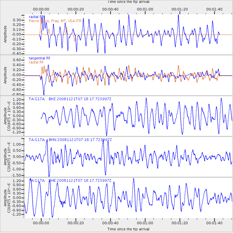
G17A Pierce Place, Pray, MT, USA - Earthquake Result Viewer
*The percent match for this event was below the threshold and hence no stack was calculated.
| Earthquake location: |
Solomon Islands |
| Earthquake latitude/longitude: |
-8.9/159.6 |
| Earthquake time(UTC): |
2008/11/21 (326) 07:05:34 GMT |
| Earthquake Depth: |
118 km |
| Earthquake Magnitude: |
6.0 MB, 6.1 MW, 6.0 MW |
| Earthquake Catalog/Contributor: |
WHDF/NEIC |
|
| Network: |
TA USArray Transportable Network (new EarthScope stations) |
| Station: |
G17A Pierce Place, Pray, MT, USA |
| Lat/Lon: |
45.32 N/110.74 W |
| Elevation: |
1574 m |
|
| Distance: |
96.1 deg |
| Az: |
45.194 deg |
| Baz: |
263.499 deg |
| Ray Param: |
$rayparam |
*The percent match for this event was below the threshold and hence was not used in the summary stack. |
|
| Radial Match: |
61.243008 % |
| Radial Bump: |
378 |
| Transverse Match: |
59.612045 % |
| Transverse Bump: |
400 |
| SOD ConfigId: |
2658 |
| Insert Time: |
2010-03-06 22:26:43.599 +0000 |
| GWidth: |
2.5 |
| Max Bumps: |
400 |
| Tol: |
0.001 |
|
Signal To Noise
| Channel | StoN | STA | LTA |
| TA:G17A: :BHN:20081121T07:18:17.723997Z | 3.1749668 | 7.3059493E-7 | 2.3011106E-7 |
| TA:G17A: :BHE:20081121T07:18:17.723997Z | 1.1227329 | 7.869217E-7 | 7.0089845E-7 |
| TA:G17A: :BHZ:20081121T07:18:17.723997Z | 0.98485434 | 3.9153954E-7 | 3.9756088E-7 |
| Arrivals |
| Ps | |
| PpPs | |
| PsPs/PpSs | |


