You are here: Home > Network List > AV - Alaska Volcano Observatory Stations List
> Station MTBL Table Top, Makushin Volcano, Alaska > Earthquake Result Viewer
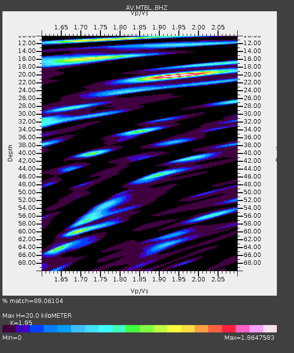
MTBL Table Top, Makushin Volcano, Alaska - Earthquake Result Viewer
| Earthquake location: |
New Britain Region, P.N.G. |
| Earthquake latitude/longitude: |
-4.1/152.6 |
| Earthquake time(UTC): |
2019/05/14 (134) 12:58:26 GMT |
| Earthquake Depth: |
10 km |
| Earthquake Magnitude: |
7.5 Mww |
| Earthquake Catalog/Contributor: |
NEIC PDE/us |
|
| Network: |
AV Alaska Volcano Observatory |
| Station: |
MTBL Table Top, Makushin Volcano, Alaska |
| Lat/Lon: |
53.97 N/166.68 W |
| Elevation: |
810 m |
|
| Distance: |
67.1 deg |
| Az: |
24.753 deg |
| Baz: |
224.985 deg |
| Ray Param: |
0.057189353 |
| Estimated Moho Depth: |
20.0 km |
| Estimated Crust Vp/Vs: |
1.95 |
| Assumed Crust Vp: |
3.943 km/s |
| Estimated Crust Vs: |
2.022 km/s |
| Estimated Crust Poisson's Ratio: |
0.32 |
|
| Radial Match: |
89.06104 % |
| Radial Bump: |
400 |
| Transverse Match: |
81.14551 % |
| Transverse Bump: |
400 |
| SOD ConfigId: |
18369291 |
| Insert Time: |
2019-05-28 12:59:52.352 +0000 |
| GWidth: |
2.5 |
| Max Bumps: |
400 |
| Tol: |
0.001 |
|

Signal To Noise
| Channel | StoN | STA | LTA |
| AV:MTBL: :BHZ:20190514T13:08:48.319972Z | 6.1793895 | 1.5357272E-6 | 2.485241E-7 |
| AV:MTBL: :BHN:20190514T13:08:48.319972Z | 1.000231 | 8.2352665E-7 | 8.2333645E-7 |
| AV:MTBL: :BHE:20190514T13:08:48.319972Z | 0.9682319 | 1.0119049E-6 | 1.045106E-6 |
| Arrivals |
| Ps | 4.9 SECOND |
| PpPs | 15 SECOND |
| PsPs/PpSs | 20 SECOND |


