You are here: Home > Network List > CN - Canadian National Seismograph Network Stations List
> Station GDR Gold River, BC, CA > Earthquake Result Viewer
GDR Gold River, BC, CA - Earthquake Result Viewer
| Earthquake location: |
New Britain Region, P.N.G. |
| Earthquake latitude/longitude: |
-4.1/152.6 |
| Earthquake time(UTC): |
2019/05/14 (134) 12:58:26 GMT |
| Earthquake Depth: |
10 km |
| Earthquake Magnitude: |
7.5 Mww |
| Earthquake Catalog/Contributor: |
NEIC PDE/us |
|
| Network: |
CN Canadian National Seismograph Network |
| Station: |
GDR Gold River, BC, CA |
| Lat/Lon: |
49.78 N/126.06 W |
| Elevation: |
123 m |
|
| Distance: |
87.5 deg |
| Az: |
39.905 deg |
| Baz: |
260.8 deg |
| Ray Param: |
0.04326295 |
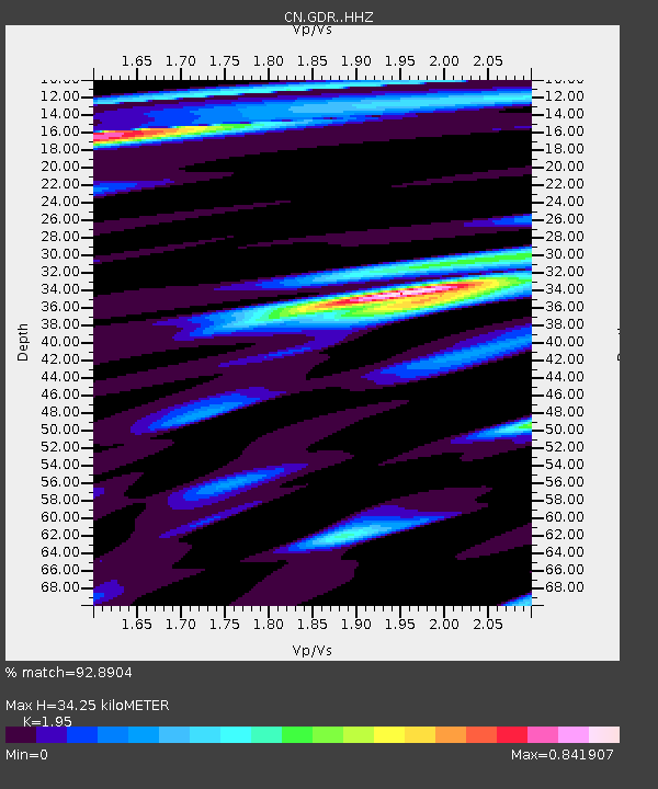
| Estimated Moho Depth: |
34.25 km |
| Estimated Crust Vp/Vs: |
1.95 |
| Assumed Crust Vp: |
6.24 km/s |
| Estimated Crust Vs: |
3.2 km/s |
| Estimated Crust Poisson's Ratio: |
0.32 |
|
| Radial Match: |
92.8904 % |
| Radial Bump: |
381 |
| Transverse Match: |
76.99085 % |
| Transverse Bump: |
400 |
| SOD ConfigId: |
18369291 |
| Insert Time: |
2019-05-28 13:00:56.187 +0000 |
| GWidth: |
2.5 |
| Max Bumps: |
400 |
| Tol: |
0.001 |
|

Signal To Noise
| Channel | StoN | STA | LTA |
| CN:GDR: :HHZ:20190514T13:10:42.459986Z | 1.4125047 | 2.9317943E-7 | 2.0755996E-7 |
| CN:GDR: :HHN:20190514T13:10:42.459986Z | 1.1137016 | 9.481684E-8 | 8.513667E-8 |
| CN:GDR: :HHE:20190514T13:10:42.459986Z | 1.8358408 | 1.8881859E-7 | 1.0285129E-7 |
| Arrivals |
| Ps | 5.3 SECOND |
| PpPs | 16 SECOND |
| PsPs/PpSs | 21 SECOND |


