You are here: Home > Network List > TS - TERRAscope (Southern California Seismic Network) Stations List
> Station GLA Glamis, California, USA > Earthquake Result Viewer
GLA Glamis, California, USA - Earthquake Result Viewer
| Earthquake location: |
Near Coast Of Nicaragua |
| Earthquake latitude/longitude: |
11.8/-87.9 |
| Earthquake time(UTC): |
1996/03/27 (087) 20:52:06 GMT |
| Earthquake Depth: |
33 km |
| Earthquake Magnitude: |
5.5 MB, 5.5 MS, 5.9 UNKNOWN, 5.4 MS |
| Earthquake Catalog/Contributor: |
WHDF/NEIC |
|
| Network: |
TS TERRAscope (Southern California Seismic Network) |
| Station: |
GLA Glamis, California, USA |
| Lat/Lon: |
33.05 N/114.83 W |
| Elevation: |
627 m |
|
| Distance: |
32.5 deg |
| Az: |
314.983 deg |
| Baz: |
124.443 deg |
| Ray Param: |
0.07858269 |
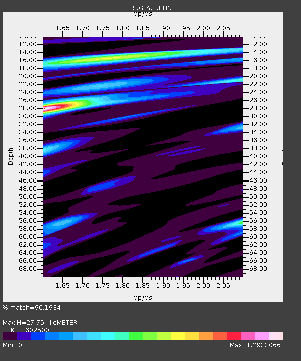
| Estimated Moho Depth: |
27.75 km |
| Estimated Crust Vp/Vs: |
1.60 |
| Assumed Crust Vp: |
6.155 km/s |
| Estimated Crust Vs: |
3.841 km/s |
| Estimated Crust Poisson's Ratio: |
0.18 |
|
| Radial Match: |
90.1934 % |
| Radial Bump: |
350 |
| Transverse Match: |
70.74579 % |
| Transverse Bump: |
400 |
| SOD ConfigId: |
9875 |
| Insert Time: |
2010-02-26 14:12:48.573 +0000 |
| GWidth: |
2.5 |
| Max Bumps: |
400 |
| Tol: |
0.001 |
|

Signal To Noise
| Channel | StoN | STA | LTA |
| TS:GLA: :BHN:19960327T20:58:03.753992Z | 1.6946058 | 2.7061756E-7 | 1.5969353E-7 |
| TS:GLA: :BHE:19960327T20:58:03.753992Z | 0.96947455 | 2.518902E-7 | 2.5982138E-7 |
| TS:GLA: :BHZ:19960327T20:58:03.753992Z | 2.0762086 | 4.1473288E-7 | 1.9975492E-7 |
| Arrivals |
| Ps | 2.9 SECOND |
| PpPs | 11 SECOND |
| PsPs/PpSs | 14 SECOND |


