You are here: Home > Network List > TA - USArray Transportable Network (new EarthScope stations) Stations List
> Station A22K Sinclair Lake, AK, USA > Earthquake Result Viewer
A22K Sinclair Lake, AK, USA - Earthquake Result Viewer

| Earthquake location: |
New Britain Region, P.N.G. |
| Earthquake latitude/longitude: |
-4.1/152.6 |
| Earthquake time(UTC): |
2019/05/14 (134) 12:58:26 GMT |
| Earthquake Depth: |
10 km |
| Earthquake Magnitude: |
7.5 Mww |
| Earthquake Catalog/Contributor: |
NEIC PDE/us |
|
| Network: |
TA USArray Transportable Network (new EarthScope stations) |
| Station: |
A22K Sinclair Lake, AK, USA |
| Lat/Lon: |
71.00 N/154.97 W |
| Elevation: |
6.0 m |
|
| Distance: |
82.4 deg |
| Az: |
15.186 deg |
| Baz: |
232.932 deg |
| Ray Param: |
0.046913613 |
| Estimated Moho Depth: |
29.25 km |
| Estimated Crust Vp/Vs: |
2.10 |
| Assumed Crust Vp: |
5.782 km/s |
| Estimated Crust Vs: |
2.757 km/s |
| Estimated Crust Poisson's Ratio: |
0.35 |
|
| Radial Match: |
96.90808 % |
| Radial Bump: |
276 |
| Transverse Match: |
91.163475 % |
| Transverse Bump: |
396 |
| SOD ConfigId: |
18369291 |
| Insert Time: |
2019-05-28 13:03:03.005 +0000 |
| GWidth: |
2.5 |
| Max Bumps: |
400 |
| Tol: |
0.001 |
|
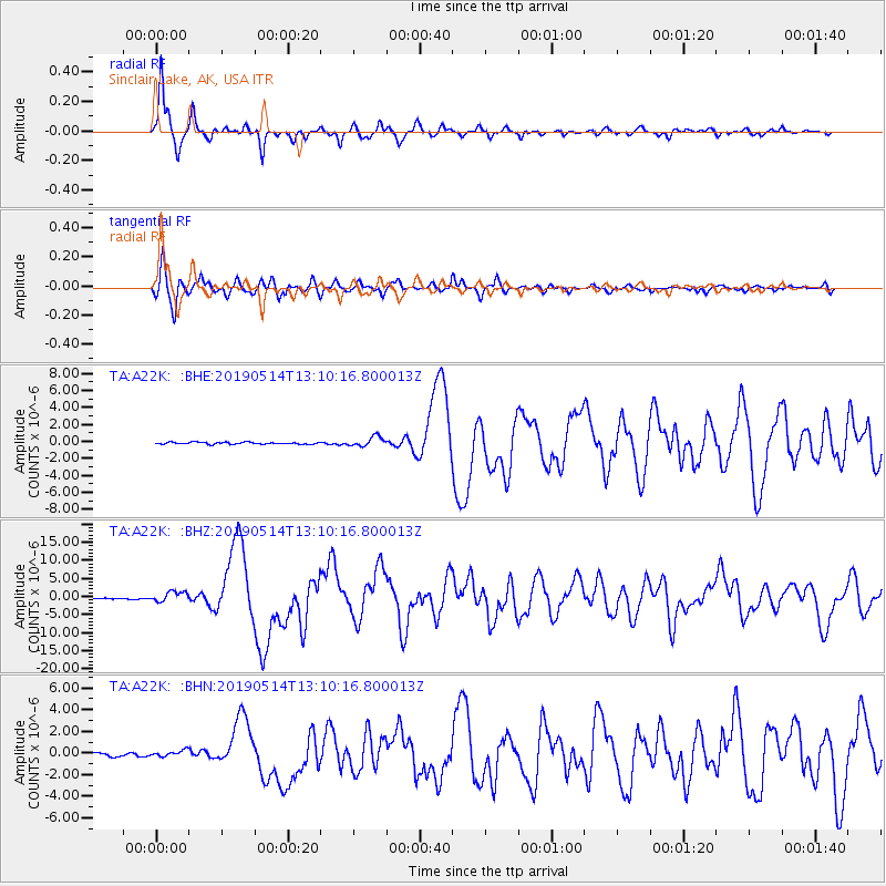
Signal To Noise
| Channel | StoN | STA | LTA |
| TA:A22K: :BHZ:20190514T13:10:16.800013Z | 15.169877 | 1.3903697E-6 | 9.165333E-8 |
| TA:A22K: :BHN:20190514T13:10:16.800013Z | 2.498327 | 2.8218057E-7 | 1.12947816E-7 |
| TA:A22K: :BHE:20190514T13:10:16.800013Z | 4.9661145 | 5.725747E-7 | 1.15296324E-7 |
| Arrivals |
| Ps | 5.7 SECOND |
| PpPs | 15 SECOND |
| PsPs/PpSs | 21 SECOND |


