You are here: Home > Network List > TA - USArray Transportable Network (new EarthScope stations) Stations List
> Station D20K Etivluk River, AK, USA > Earthquake Result Viewer
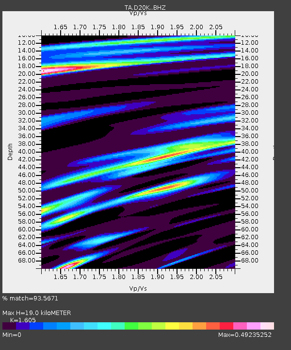
D20K Etivluk River, AK, USA - Earthquake Result Viewer
| Earthquake location: |
New Britain Region, P.N.G. |
| Earthquake latitude/longitude: |
-4.1/152.6 |
| Earthquake time(UTC): |
2019/05/14 (134) 12:58:26 GMT |
| Earthquake Depth: |
10 km |
| Earthquake Magnitude: |
7.5 Mww |
| Earthquake Catalog/Contributor: |
NEIC PDE/us |
|
| Network: |
TA USArray Transportable Network (new EarthScope stations) |
| Station: |
D20K Etivluk River, AK, USA |
| Lat/Lon: |
68.71 N/156.61 W |
| Elevation: |
577 m |
|
| Distance: |
80.5 deg |
| Az: |
16.675 deg |
| Baz: |
231.615 deg |
| Ray Param: |
0.04820493 |
| Estimated Moho Depth: |
19.0 km |
| Estimated Crust Vp/Vs: |
1.61 |
| Assumed Crust Vp: |
6.221 km/s |
| Estimated Crust Vs: |
3.876 km/s |
| Estimated Crust Poisson's Ratio: |
0.18 |
|
| Radial Match: |
93.5671 % |
| Radial Bump: |
400 |
| Transverse Match: |
84.64544 % |
| Transverse Bump: |
400 |
| SOD ConfigId: |
18369291 |
| Insert Time: |
2019-05-28 13:03:12.295 +0000 |
| GWidth: |
2.5 |
| Max Bumps: |
400 |
| Tol: |
0.001 |
|

Signal To Noise
| Channel | StoN | STA | LTA |
| TA:D20K: :BHZ:20190514T13:10:07.000025Z | 14.868331 | 1.3650726E-6 | 9.1810755E-8 |
| TA:D20K: :BHN:20190514T13:10:07.000025Z | 3.5262535 | 2.1780964E-7 | 6.1768006E-8 |
| TA:D20K: :BHE:20190514T13:10:07.000025Z | 4.050602 | 2.972595E-7 | 7.338651E-8 |
| Arrivals |
| Ps | 1.9 SECOND |
| PpPs | 7.7 SECOND |
| PsPs/PpSs | 9.6 SECOND |


