You are here: Home > Network List > TA - USArray Transportable Network (new EarthScope stations) Stations List
> Station E19K Redstone River, AK, USA > Earthquake Result Viewer
E19K Redstone River, AK, USA - Earthquake Result Viewer
| Earthquake location: |
New Britain Region, P.N.G. |
| Earthquake latitude/longitude: |
-4.1/152.6 |
| Earthquake time(UTC): |
2019/05/14 (134) 12:58:26 GMT |
| Earthquake Depth: |
10 km |
| Earthquake Magnitude: |
7.5 Mww |
| Earthquake Catalog/Contributor: |
NEIC PDE/us |
|
| Network: |
TA USArray Transportable Network (new EarthScope stations) |
| Station: |
E19K Redstone River, AK, USA |
| Lat/Lon: |
67.46 N/157.23 W |
| Elevation: |
441 m |
|
| Distance: |
79.6 deg |
| Az: |
17.53 deg |
| Baz: |
231.189 deg |
| Ray Param: |
0.048867814 |
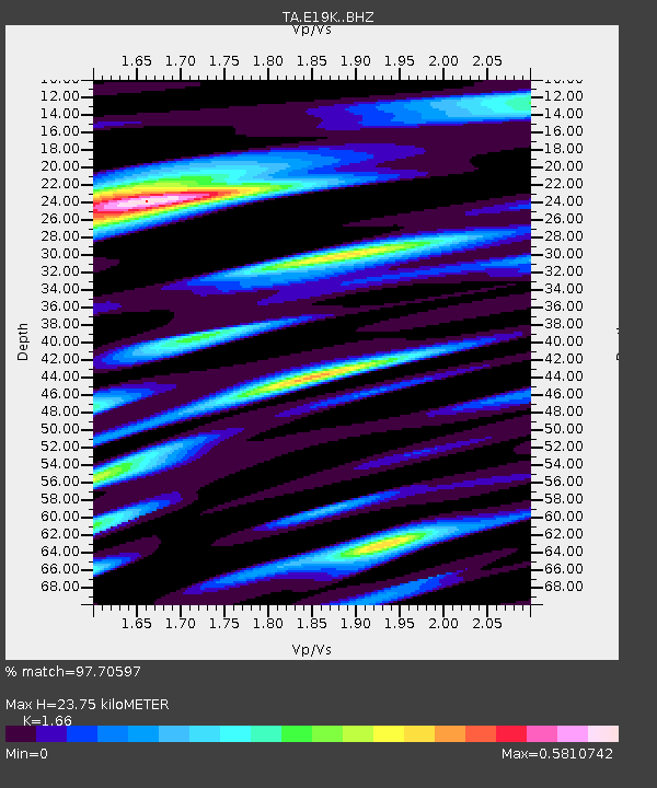
| Estimated Moho Depth: |
23.75 km |
| Estimated Crust Vp/Vs: |
1.66 |
| Assumed Crust Vp: |
6.577 km/s |
| Estimated Crust Vs: |
3.962 km/s |
| Estimated Crust Poisson's Ratio: |
0.22 |
|
| Radial Match: |
97.70597 % |
| Radial Bump: |
317 |
| Transverse Match: |
89.477615 % |
| Transverse Bump: |
400 |
| SOD ConfigId: |
18369291 |
| Insert Time: |
2019-05-28 13:03:16.971 +0000 |
| GWidth: |
2.5 |
| Max Bumps: |
400 |
| Tol: |
0.001 |
|

Signal To Noise
| Channel | StoN | STA | LTA |
| TA:E19K: :BHZ:20190514T13:10:01.800013Z | 11.623479 | 1.3084382E-6 | 1.1256855E-7 |
| TA:E19K: :BHN:20190514T13:10:01.800013Z | 6.052427 | 2.831192E-7 | 4.67778E-8 |
| TA:E19K: :BHE:20190514T13:10:01.800013Z | 8.410985 | 3.8712415E-7 | 4.6026017E-8 |
| Arrivals |
| Ps | 2.5 SECOND |
| PpPs | 9.3 SECOND |
| PsPs/PpSs | 12 SECOND |


