You are here: Home > Network List > TS - TERRAscope (Southern California Seismic Network) Stations List
> Station GLA Glamis, California, USA > Earthquake Result Viewer
GLA Glamis, California, USA - Earthquake Result Viewer
| Earthquake location: |
Off East Coast Of Kamchatka |
| Earthquake latitude/longitude: |
51.4/159.2 |
| Earthquake time(UTC): |
1996/06/22 (174) 14:50:07 GMT |
| Earthquake Depth: |
33 km |
| Earthquake Magnitude: |
5.6 MB, 6.0 MS, 6.2 UNKNOWN, 6.2 MW |
| Earthquake Catalog/Contributor: |
WHDF/NEIC |
|
| Network: |
TS TERRAscope (Southern California Seismic Network) |
| Station: |
GLA Glamis, California, USA |
| Lat/Lon: |
33.05 N/114.83 W |
| Elevation: |
627 m |
|
| Distance: |
62.6 deg |
| Az: |
70.683 deg |
| Baz: |
315.256 deg |
| Ray Param: |
0.060074348 |
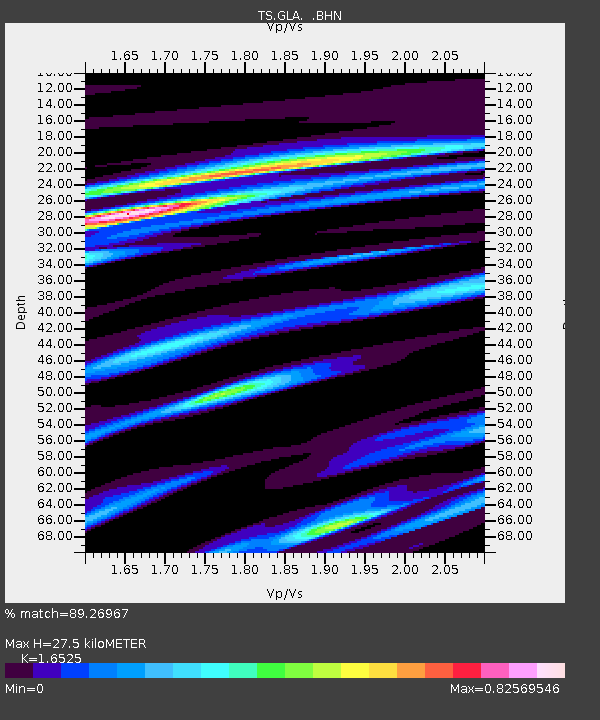
| Estimated Moho Depth: |
27.5 km |
| Estimated Crust Vp/Vs: |
1.65 |
| Assumed Crust Vp: |
6.155 km/s |
| Estimated Crust Vs: |
3.724 km/s |
| Estimated Crust Poisson's Ratio: |
0.21 |
|
| Radial Match: |
89.26967 % |
| Radial Bump: |
400 |
| Transverse Match: |
79.24883 % |
| Transverse Bump: |
400 |
| SOD ConfigId: |
6273 |
| Insert Time: |
2010-02-26 14:12:50.551 +0000 |
| GWidth: |
2.5 |
| Max Bumps: |
400 |
| Tol: |
0.001 |
|

Signal To Noise
| Channel | StoN | STA | LTA |
| TS:GLA: :BHN:19960622T14:59:57.551025Z | 0.9415497 | 1.0303257E-7 | 1.09428704E-7 |
| TS:GLA: :BHE:19960622T14:59:57.551025Z | 1.0602835 | 1.0741523E-7 | 1.0130803E-7 |
| TS:GLA: :BHZ:19960622T14:59:57.551025Z | 1.04767 | 8.892509E-8 | 8.487891E-8 |
| Arrivals |
| Ps | 3.0 SECOND |
| PpPs | 11 SECOND |
| PsPs/PpSs | 14 SECOND |


