You are here: Home > Network List > TS - TERRAscope (Southern California Seismic Network) Stations List
> Station GLA Glamis, California, USA > Earthquake Result Viewer
GLA Glamis, California, USA - Earthquake Result Viewer
| Earthquake location: |
Fiji Islands |
| Earthquake latitude/longitude: |
-16.1/178.1 |
| Earthquake time(UTC): |
1996/06/18 (170) 13:55:34 GMT |
| Earthquake Depth: |
33 km |
| Earthquake Magnitude: |
5.6 MB, 5.4 MS, 6.0 UNKNOWN, 5.9 MW |
| Earthquake Catalog/Contributor: |
WHDF/NEIC |
|
| Network: |
TS TERRAscope (Southern California Seismic Network) |
| Station: |
GLA Glamis, California, USA |
| Lat/Lon: |
33.05 N/114.83 W |
| Elevation: |
627 m |
|
| Distance: |
80.5 deg |
| Az: |
51.647 deg |
| Baz: |
243.858 deg |
| Ray Param: |
0.048203968 |
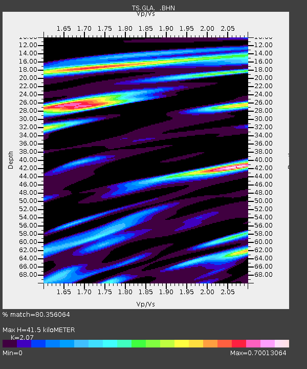
| Estimated Moho Depth: |
41.5 km |
| Estimated Crust Vp/Vs: |
2.07 |
| Assumed Crust Vp: |
6.155 km/s |
| Estimated Crust Vs: |
2.973 km/s |
| Estimated Crust Poisson's Ratio: |
0.35 |
|
| Radial Match: |
80.356064 % |
| Radial Bump: |
400 |
| Transverse Match: |
68.73184 % |
| Transverse Bump: |
400 |
| SOD ConfigId: |
6273 |
| Insert Time: |
2010-02-26 14:12:51.622 +0000 |
| GWidth: |
2.5 |
| Max Bumps: |
400 |
| Tol: |
0.001 |
|

Signal To Noise
| Channel | StoN | STA | LTA |
| TS:GLA: :BHN:19960618T14:07:11.700Z | 0.9373655 | 8.561101E-8 | 9.133152E-8 |
| TS:GLA: :BHE:19960618T14:07:11.700Z | 1.4961456 | 9.162257E-8 | 6.123907E-8 |
| TS:GLA: :BHZ:19960618T14:07:11.700Z | 5.3469663 | 2.4559915E-7 | 4.5932428E-8 |
| Arrivals |
| Ps | 7.4 SECOND |
| PpPs | 20 SECOND |
| PsPs/PpSs | 28 SECOND |


