You are here: Home > Network List > TA - USArray Transportable Network (new EarthScope stations) Stations List
> Station K15K Wolf Creek Mountain, AK, USA > Earthquake Result Viewer
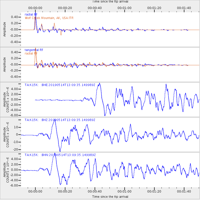
K15K Wolf Creek Mountain, AK, USA - Earthquake Result Viewer
| Earthquake location: |
New Britain Region, P.N.G. |
| Earthquake latitude/longitude: |
-4.1/152.6 |
| Earthquake time(UTC): |
2019/05/14 (134) 12:58:26 GMT |
| Earthquake Depth: |
10 km |
| Earthquake Magnitude: |
7.5 Mww |
| Earthquake Catalog/Contributor: |
NEIC PDE/us |
|
| Network: |
TA USArray Transportable Network (new EarthScope stations) |
| Station: |
K15K Wolf Creek Mountain, AK, USA |
| Lat/Lon: |
62.29 N/161.53 W |
| Elevation: |
346 m |
|
| Distance: |
74.8 deg |
| Az: |
20.352 deg |
| Baz: |
227.923 deg |
| Ray Param: |
0.052080706 |
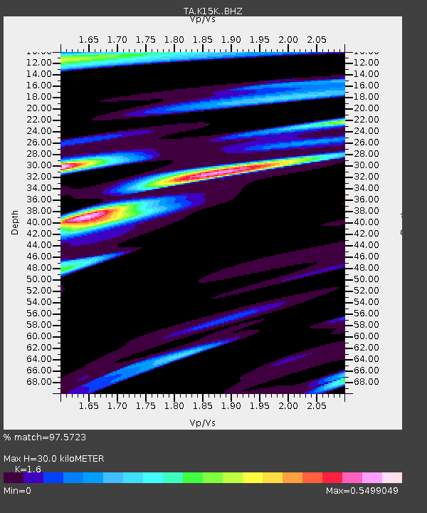
| Estimated Moho Depth: |
30.0 km |
| Estimated Crust Vp/Vs: |
1.60 |
| Assumed Crust Vp: |
6.276 km/s |
| Estimated Crust Vs: |
3.922 km/s |
| Estimated Crust Poisson's Ratio: |
0.18 |
|
| Radial Match: |
97.5723 % |
| Radial Bump: |
330 |
| Transverse Match: |
84.19089 % |
| Transverse Bump: |
400 |
| SOD ConfigId: |
18369291 |
| Insert Time: |
2019-05-28 13:03:55.667 +0000 |
| GWidth: |
2.5 |
| Max Bumps: |
400 |
| Tol: |
0.001 |
|
Signal To Noise
| Channel | StoN | STA | LTA |
| TA:K15K: :BHZ:20190514T13:09:35.149989Z | 9.358905 | 1.3673836E-6 | 1.4610508E-7 |
| TA:K15K: :BHN:20190514T13:09:35.149989Z | 4.390376 | 4.1905372E-7 | 9.544825E-8 |
| TA:K15K: :BHE:20190514T13:09:35.149989Z | 5.3874226 | 4.2073697E-7 | 7.809616E-8 |
| Arrivals |
| Ps | 3.0 SECOND |
| PpPs | 12 SECOND |
| PsPs/PpSs | 15 SECOND |


