You are here: Home > Network List > TA - USArray Transportable Network (new EarthScope stations) Stations List
> Station G17A Pierce Place, Pray, MT, USA > Earthquake Result Viewer
G17A Pierce Place, Pray, MT, USA - Earthquake Result Viewer
*The percent match for this event was below the threshold and hence no stack was calculated.
| Earthquake location: |
Santa Cruz Islands |
| Earthquake latitude/longitude: |
-11.4/166.2 |
| Earthquake time(UTC): |
2008/08/12 (225) 05:25:57 GMT |
| Earthquake Depth: |
38 km |
| Earthquake Magnitude: |
5.9 MW, 5.4 MS, 5.2 MB, 5.8 MW |
| Earthquake Catalog/Contributor: |
WHDF/NEIC |
|
| Network: |
TA USArray Transportable Network (new EarthScope stations) |
| Station: |
G17A Pierce Place, Pray, MT, USA |
| Lat/Lon: |
45.32 N/110.74 W |
| Elevation: |
1574 m |
|
| Distance: |
93.2 deg |
| Az: |
44.538 deg |
| Baz: |
257.08 deg |
| Ray Param: |
$rayparam |
*The percent match for this event was below the threshold and hence was not used in the summary stack. |
|
| Radial Match: |
56.5436 % |
| Radial Bump: |
348 |
| Transverse Match: |
47.875805 % |
| Transverse Bump: |
369 |
| SOD ConfigId: |
2504 |
| Insert Time: |
2010-03-06 22:28:01.926 +0000 |
| GWidth: |
2.5 |
| Max Bumps: |
400 |
| Tol: |
0.001 |
|
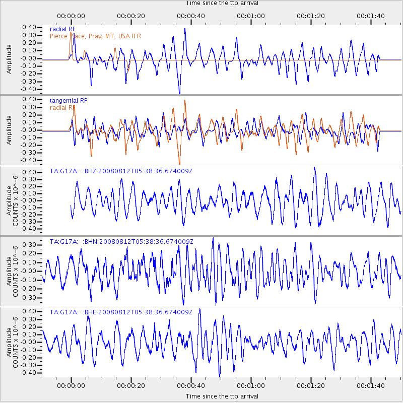
Signal To Noise
| Channel | StoN | STA | LTA |
| TA:G17A: :BHN:20080812T05:38:36.674009Z | 1.741885 | 1.3248007E-7 | 7.6055585E-8 |
| TA:G17A: :BHE:20080812T05:38:36.674009Z | 1.2621258 | 1.4657448E-7 | 1.16133016E-7 |
| TA:G17A: :BHZ:20080812T05:38:36.674009Z | 0.7356537 | 1.11284585E-7 | 1.5127306E-7 |
| Arrivals |
| Ps | |
| PpPs | |
| PsPs/PpSs | |


