You are here: Home > Network List > TA - USArray Transportable Network (new EarthScope stations) Stations List
> Station G17A Pierce Place, Pray, MT, USA > Earthquake Result Viewer
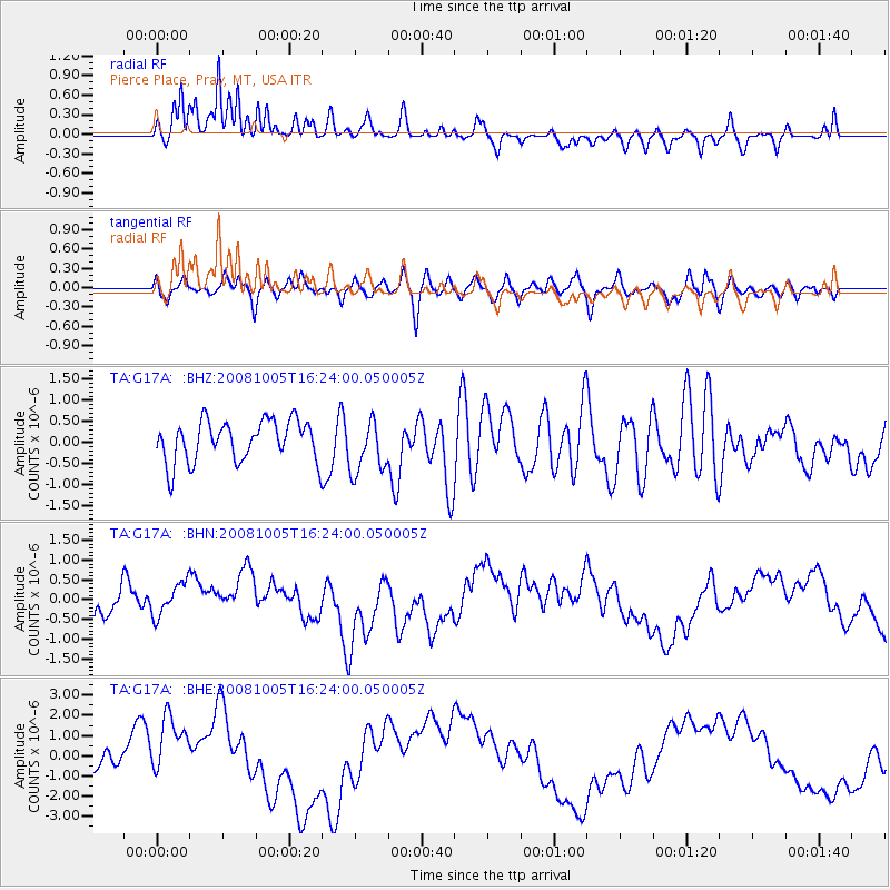
G17A Pierce Place, Pray, MT, USA - Earthquake Result Viewer
*The percent match for this event was below the threshold and hence no stack was calculated.
| Earthquake location: |
Tajikistan-Xinjiang Border Reg. |
| Earthquake latitude/longitude: |
39.5/73.9 |
| Earthquake time(UTC): |
2008/10/05 (279) 16:11:10 GMT |
| Earthquake Depth: |
35 km |
| Earthquake Magnitude: |
5.6 MB |
| Earthquake Catalog/Contributor: |
WHDF/NEIC |
|
| Network: |
TA USArray Transportable Network (new EarthScope stations) |
| Station: |
G17A Pierce Place, Pray, MT, USA |
| Lat/Lon: |
45.32 N/110.74 W |
| Elevation: |
1574 m |
|
| Distance: |
95.4 deg |
| Az: |
3.278 deg |
| Baz: |
356.405 deg |
| Ray Param: |
$rayparam |
*The percent match for this event was below the threshold and hence was not used in the summary stack. |
|
| Radial Match: |
67.59034 % |
| Radial Bump: |
331 |
| Transverse Match: |
50.3731 % |
| Transverse Bump: |
400 |
| SOD ConfigId: |
2556 |
| Insert Time: |
2010-03-06 22:28:14.506 +0000 |
| GWidth: |
2.5 |
| Max Bumps: |
400 |
| Tol: |
0.001 |
|
Signal To Noise
| Channel | StoN | STA | LTA |
| TA:G17A: :BHN:20081005T16:24:00.050005Z | 1.2801547 | 4.685106E-7 | 3.6597967E-7 |
| TA:G17A: :BHE:20081005T16:24:00.050005Z | 1.9999459 | 1.6343091E-6 | 8.1717667E-7 |
| TA:G17A: :BHZ:20081005T16:24:00.050005Z | 1.3162768 | 6.372204E-7 | 4.841082E-7 |
| Arrivals |
| Ps | |
| PpPs | |
| PsPs/PpSs | |


