You are here: Home > Network List > TA - USArray Transportable Network (new EarthScope stations) Stations List
> Station P08K Saint George Island, AK, USA > Earthquake Result Viewer
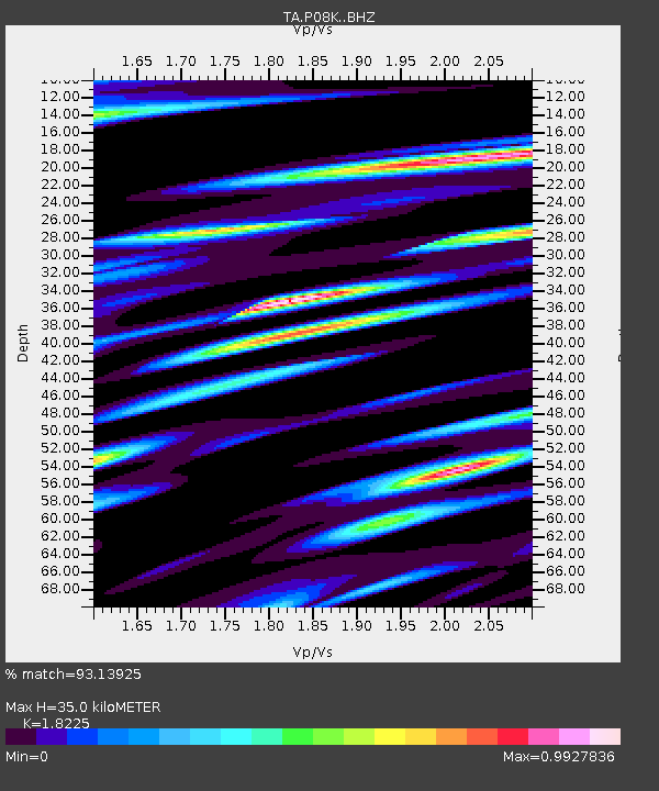
P08K Saint George Island, AK, USA - Earthquake Result Viewer
| Earthquake location: |
New Britain Region, P.N.G. |
| Earthquake latitude/longitude: |
-4.1/152.6 |
| Earthquake time(UTC): |
2019/05/14 (134) 12:58:26 GMT |
| Earthquake Depth: |
10 km |
| Earthquake Magnitude: |
7.5 Mww |
| Earthquake Catalog/Contributor: |
NEIC PDE/us |
|
| Network: |
TA USArray Transportable Network (new EarthScope stations) |
| Station: |
P08K Saint George Island, AK, USA |
| Lat/Lon: |
56.60 N/169.55 W |
| Elevation: |
36 m |
|
| Distance: |
67.9 deg |
| Az: |
21.504 deg |
| Baz: |
221.388 deg |
| Ray Param: |
0.05666691 |
| Estimated Moho Depth: |
35.0 km |
| Estimated Crust Vp/Vs: |
1.82 |
| Assumed Crust Vp: |
6.24 km/s |
| Estimated Crust Vs: |
3.424 km/s |
| Estimated Crust Poisson's Ratio: |
0.28 |
|
| Radial Match: |
93.13925 % |
| Radial Bump: |
400 |
| Transverse Match: |
80.65933 % |
| Transverse Bump: |
400 |
| SOD ConfigId: |
18369291 |
| Insert Time: |
2019-05-28 13:04:22.730 +0000 |
| GWidth: |
2.5 |
| Max Bumps: |
400 |
| Tol: |
0.001 |
|

Signal To Noise
| Channel | StoN | STA | LTA |
| TA:P08K: :BHZ:20190514T13:08:53.375025Z | 2.9138153 | 1.7626791E-6 | 6.049385E-7 |
| TA:P08K: :BHN:20190514T13:08:53.375025Z | 0.8784668 | 9.709264E-7 | 1.1052512E-6 |
| TA:P08K: :BHE:20190514T13:08:53.375025Z | 1.4415344 | 1.3887167E-6 | 9.6336E-7 |
| Arrivals |
| Ps | 4.8 SECOND |
| PpPs | 15 SECOND |
| PsPs/PpSs | 20 SECOND |


